

A trickle, not a flood: environmental watering in the Murray–Darling Basin, Australia
Yiwen Chen A B , Matthew J. Colloff A , Anna Lukasiewicz A and Jamie Pittock A
A Fenner School of Environment and Society, The Australian National University, Building 141, Linnaeus Way, Canberra, ACT 2601, Australia.
B Corresponding author. Email: evechen1996@gmail.com
Marine and Freshwater Research 72(5) 601-619 https://doi.org/10.1071/MF20172
Submitted: 1 June 2020 Accepted: 22 October 2020 Published: 19 November 2020
Journal Compilation © CSIRO 2021 Open Access CC BY
Abstract
Environmental flows are an integral component for the conservation and management of rivers, flood plains and other wetlands in the Murray–Darling Basin. Under the Basin Plan, environmental water is managed by the Commonwealth Environmental Water Office (CEWO) and the states. We assessed CEWO environmental flows (2014–15 to 2018–19), compared our findings with expected outcomes for vegetation in the Basin-wide Environmental Watering Strategy (EWS) and interviewed water managers about the efficacy of environmental watering. Some 21% of CEWO water was delivered as flood events, to 9 of 19 river valleys, inundating 7% of wetland area in those valleys annually and 0.8% of major Basin wetlands. A consistent pattern was the watering of many small wetlands on the South Australian Murray with small volumes (median area 43 ha, volume 125 ML). Just 12% of the area of river red gum subject to EWS expected outcomes was flooded, and half these events were likely suboptimal to achieve ecological benefits. Wetlands have not received the water they need and vegetation outcomes cannot be met by completion of the Plan in 2024. Rules that constrain flooding of private land must be relaxed if the Plan is to achieve its statutory requirement of wetland conservation.
Keywords: adaptive management, environmental flows, environmental water accounting, floods, mixed methods, Murray–Darling Basin Plan, triage, water policy, wetlands.
Introduction
The Murray–Darling Basin (hereafter, the Basin) covers 1.06 × 10⁶ km2 of south-eastern Australia and contains ~30 000 wetlands of 25 000 km2 in area, including 6363 km2 of some 16 Ramsar wetlands (Murray–Darling Basin Authority 2010a, p. 59). Over 100 wetlands are of national importance (Environment Australia 2001), but only 10% of the area of the Basin, is designated for conservation; the rest is mostly dryland pasture (69%) and arable land (12%). Irrigated agriculture accounts for <3% of the area (Australian Bureau of Statistics, Australian Bureau of Agricultural and Resource Economics, and Bureau of Rural Sciences 2009), but 46% of the surface water available (the remaining 54% being river outflows, transmission losses and urban water use; CSIRO 2008, p. 32). Many irrigation districts are close to major wetlands (Fig. 1). The high level of surface water use highlights the contestation between water for irrigation and the environment, an issue that is central to an understanding of the Basin as a social–ecological system and to past and current efforts in water reform policy and management (Connell and Grafton 2011; Wentworth Group 2017; Grafton 2019; Grafton et al. 2020).

|
Rivers and other wetlands of the Basin were heavily modified during the 19th century. Major stressors included grazing, timber harvesting and land clearing (Colloff 2014; Colloff et al. 2015). Subsequent stressors were river regulation and irrigation water diversions, which increased sharply between 1950 and 1990 (Kingsford 2000; Colloff et al. 2015). River flows were further reduced by extended drought (van Dijk et al. 2013), climate change (Cai and Cowan 2008), flood plain harvesting (i.e. interception and storage on-farm of overland flows; Steinfeld and Kingsford 2013) and recent increases in irrigation water use, including illegal, unlicensed and unregulated diversions (Wheeler et al. 2020).
The climate of the Basin is mostly arid to semi-arid, with mean annual rainfall <500 mm and major droughts at median intervals of 9 years since 1800 (Colloff 2014, fig. 8.1 therein). Strong gradients of rainfall (east–west) and evapotranspiration (north–south) occur, with rainfall mostly in summer in the northern Basin and during winter and early spring in the south (Chiew et al. 2008), the seasons in which river discharge was naturally highest and natural floods occurred before river regulation and water resource development. Releases of irrigation water from headwater dams during summer have reversed the seasonal pattern of high flows in southern Basin rivers and maximum discharge has been considerably reduced (CSIRO 2008, p. 54), resulting in fewer, shorter, less frequent and extensive floods.
Altered flow and flood regimes vary spatially across the Basin, with greatest changes in the southern Basin, which has a far longer history of regulation and irrigation water use than the north (Sims et al. 2012). This variation is reflected in the condition of river valleys, determined by the Sustainable Rivers Audit (Davies et al. 2010, 2012). For the assessment period 2004–07, in the northern Basin, only the unregulated Paroo River valley was ranked in good health; four valleys were ranked as moderate, and four as poor or very poor. In the southern Basin, one valley was ranked as in moderate health and thirteen as poor or very poor health (Davies et al. 2010).
In response to the overallocation of water for irrigation and the poor condition of flow-dependent ecosystems, the Australian Government initiated a series of water reforms to balance water use for irrigation and the environment and to promote sustainable water management by the National Water Initiative (National Water Commission 2004). These reforms are underpinned by the Commonwealth Water Act (2007). The Basin Plan (Commonwealth of Australia 2012; hereafter, ‘the Plan’) is a statutory instrument under the Water Act for returning water to the environment by reducing the amount taken by irrigators.
The environmental objectives of the Plan are to protect and restore flow-, flood- and groundwater-dependent ecosystems (or ‘water-dependent ecosystems’ in the Plan; i.e. rivers, lakes, flood plains and other wetlands) and ensure they are resilient to climate change and other threats (Commonwealth of Australia 2012, p. 25). The Plan sets out a process to identify the environmentally sustainable level of take (ESLT) by setting a sustainable diversion limit (SDL) for the Basin. This process involves assessing the water requirements of 124 ‘hydrologic indicator sites’ (Murray–Darling Basin Authority 2012a) in order to determine the environmental water requirements to conserve ecosystems as required under the Water Act (Murray–Darling Basin Authority 2010b, p. 487; Commonwealth of Australia 2012, S6.01, S6.03; Walker 2019, pp. 201-204). Flows at these sites are assumed to represent the environmental water needs of rivers and other wetlands more broadly across the Basin. However, this assumption was part of the planning process and has not been corroborated empirically.
The Commonwealth Department of Agriculture is responsible for recovering water from irrigators and the Murray–Darling Basin Authority (MDBA) is responsible for the Plan, including setting SDLs. The SDLs are implemented by water resource plans administered by the states. Under the SDLs, an average of 2750 GL year–1 is intended to be reallocated from irrigators to the environment, with a further 450 GL year–1 to be recovered through improved irrigation water use efficiency. The Commonwealth Environmental Water Office (CEWO) manages environmental water recovered from irrigators (Docker and Robinson 2014). These arrangements, together with the wide range of water users and stakeholders in the Basin with differing interests, perspective and values, create a complex and contested social and political context for the delivery and use of environmental water (Colloff and Pittock 2019; Grafton et al. 2020).
Environmental objectives include maintaining river connectivity and native vegetation and increasing populations of waterbirds and native fish, as well as conserving Ramsar sites and other ecologically important wetlands (Murray–Darling Basin Authority 2019a). Environmental water to achieve these objectives is partitioned among jurisdictions and includes water held by the Commonwealth (CEWO), New South Wales (NSW), Victoria and South Australia and jointly with the MDBA under the Living Murray program (TLM; Murray–Darling Basin Authority 2011), as well as volumes for specified purposes under various water sharing agreements, such as the Barmah-Millewa environmental water allowance, established in 1993 by the Murray–Darling Basin Ministerial Council (Schofield et al. 2003, p. 24). In Queensland, environmental water is protected in water resource plans for each river valley by rules on access to water, rather than by specific allocations.
The CEWO partners with states and other water holders in sharing contributions to environmental water for release in most river valleys (see Table S1 in the Supplementary material to this paper, for relative contributions by valley and Murray–Darling Basin Authority (2019a, pp. 74–79) and Commonwealth Environmental Water Office (2013, pp. 8–10, 19–21) for operational details). Annual environmental watering priorities are set by the MDBA at the beginning of each water year (e.g. Murray–Darling Basin Authority 2018a). The priorities (which are essentially objectives) are intended to support the expected environmental outcomes detailed in the Basin-wide Environmental Watering Strategy (EWS; Murray–Darling Basin Authority 2019a) and hence the ecological objectives and expected outcomes in the Plan. Environmental outcomes are monitored by the states and on behalf of CEWO, which forms a basis for implementation of adaptive management (Murray–Darling Basin Authority 2017).
In NSW, most shared environmental water releases that involved flood events are for major wetlands, particularly Gwydir and Mallowa wetlands, Macquarie Marshes, Great Cumbung, Booligal and Lachlan swamps, the mid- and lower-Murrumbidgee wetlands and Central Murray forests, with contributions from TLM to the latter (Table S2). In Victoria, most shared releases by valley are in the Central Murray and Goulburn–Broken, as well as for Hattah Lakes, with small shared contributions in the Campaspe and Loddon. In South Australia, most pooled releases are for the Riverland–Chowilla Floodplain and Lindsay–Walpolla. The end-of-system Coorong and Lower lakes receive contributions of environmental water from CEWO, three states and TLM (Table S2).
The plethora of environmental watering arrangements has led to a complex, rules-based culture of decision making, monitoring and reporting. The Plan has been presented as an exercise in adaptive management (Murray–Darling Basin Authority 2017; Watts et al. 2020; Gawne et al. 2020). But it remains unclear how lessons learned can be integrated into the Plan outside its rigid rules and timelines: the Plan is subject to 5-yearly review and is due to be fully operational in 2024. In an example of maladaptive decision making, it was recommended that accounting for effects of climate change, not included in the setting of the SDLs, should only be considered when the plan is due for review in 2026 (Vertessy et al. 2019, p. 14), despite record temperatures in 2017, 2018 and 2019 during the worst drought in recent history and the acknowledgement by the Murray–Darling Basin Authority (2019b, p. 3) of the need to adapt to a future with less water than was planned in 2012.
Many uncertainties remain over how environmental objectives will be achieved (King et al. 2015; Thompson et al. 2019) and there is as yet no synthesis of outcomes at Basin scale that collates site-based monitoring data. Site-specific benefits have been reported, including improved vegetation condition (Capon and Campbell 2017) and fish breeding (NSW Office of Environment and Heritage 2017, p. 27) but these have tended to be small scale and short term (Colloff and Pittock 2019; Moxham et al. 2019).
Reporting of environmental watering is fragmented, in annual reports by CEWO, state agencies and others, with duplication of locations, events, water sources and volumes, as well as inconsistencies in data and reporting regions. To assess watering in the Basin for 2016–17, one has to consult seven reports: NSW Office of Environment and Heritage (2017); Department of Environment, Water and Natural Resources (2017); Victorian Environmental Water Holder (2017a, 2017b); Hale et al. (2018), Murray–Darling Basin Authority (2018b) and Commonwealth Environmental Water Office (2020a). A confounding issue in monitoring and reporting is the difficulty in apportioning outcomes achieved from Commonwealth environmental water from that of other water holdings released concurrently, as well as from natural, or unregulated, river flows.
The multiple agencies involved in monitoring and reporting create additional uncertainty and inconsistency at Basin scale. Annual reports may provide some detail for a few major watering events, but tend only to specify the volume delivered to particular rivers and other wetlands and lack basic data, including areas of wetlands inundated, depth and duration of flood events (including peak discharge, rates and duration of rise and recession) and whether objectives were met. It is challenging and time-consuming to determine who did what, where, when and how, the sources of water involved and what happened. Thus, it is not clear that best practice monitoring is being done, particularly the use of underpinning conceptual ecosystem models, the setting of good questions, hypotheses and objectives and specific monitoring and reporting on these (Lindenmayer and Likens 2018, pp. 60–66). Accordingly, there is growing concern whether environmental flows released to date are sufficient to achieve planned ecological outcomes at Basin scale (Colloff and Pittock 2019).
Our aims in this study were to assess how and where environmental water has been used by federal and state government agencies and their partners for the period 2012–13 to 2018–19 (i.e. from the commencement of the implementation of the Plan). We also assessed the nature and extent of environmental watering by CEWO of floodplain wetlands and of wetland woody vegetation communities that are the subject of targets for the maintenance of their extent and condition under the Basin-wide EWS (Murray–Darling Basin Authority 2019a). We focussed on wetland woody vegetation communities because of their important role in primary productivity, carbon and nutrient cycling and habitat provision in many wetlands and because their nature and extent are defining features of the ecological character of wetlands listed under the Ramsar Convention (Murray–Darling Basin Authority 2019a, p. 33). An important requirement of the Ramsar Convention is that the ecological character of all wetlands should be maintained, not just that of Ramsar sites (Pittock et al. 2010, p. 403). The Water Act represents a law, and the Plan a legal instrument, that implements Commonwealth obligations with respect to external affairs under international environmental treaties, including the Ramsar Convention (Walker 2019, p. 107).
We used data for the water years from 2014–15 to 2018–19, coinciding with improved reporting of individual watering events by CEWO. This is also the period when Commonwealth environmental water entitlements reached 2100 GL year–1, close to the maximum likely to be acquired for the foreseeable future because of political compromises on approaches to water recovery. We assessed the watering of floodplain wetlands rather than in-channel flows because of the many nationally and internationally significant wetlands in the Basin. Also, the flooding of wetlands generates bioavailable carbon and nutrients that return to the river channel downstream and drive within-channel aquatic food webs (Rees et al. 2020). We evaluated whether environmental water could be considered to have been delivered efficiently and effectively by conducting interviews with staff from government agencies who are involved in policy and management of environmental flows.
Materials and methods
We used a mixed-methods approach, involving both quantitative and qualitative data (Harwell 2011). We collated data on environmental flow events across the Basin, which then informed our formulation of questions for interviews with environmental water managers. Qualitative semistructured interviews were used to cross-reference quantitative findings with professionals with experience in water management and policy, including the clarification of problems and discrepancies, and provided important insights into constraints and risks in policy and management of environmental flows. We considered that cross-referencing of quantitative findings to inform questions asked during interviews would enable a deeper understanding of environmental water issues than from a quantitative analysis alone.
Environmental water releases
We collated data on the volume of environmental water released by the Commonwealth and states in each river valley in the Basin between 2012–13 and 2018–19, covering the first 7 years of the Plan. Data were sourced from CEWO and state annual reports (see sources of data used in Table S1). We assessed the volume attributed to the Commonwealth Environmental Water Holder (CEWH), States (NSW, South Australia and Victoria) and other sources, including TLM, environmental water allocations (EWA) under water sharing plans in NSW and water from the Snowy Scheme (‘River Murray increased flows’). We note that total volumes of environmental water delivered in the Basin by CEWO 2012–13 to 2018–19, as reported by the Department of Agriculture, Water and the Environment (2020), are lower than the sum of the volumes in the CEWO long-term intervention monitoring (LTIM) reports (e.g. Gawne et al. 2016; Hale et al. 2020, appendix A). The former are net total use (i.e. the volumes of environmental water actually released), whereas the LTIM volumes include return flows from River Murray tributaries that are available for reuse after they enter the Murray. We used net total use to avoid double counting and in order to assess the overall contribution from each jurisdiction. Data on net total use is not broken down by river valley, so we used LTIM figures for valleys (Table S1), noting that the risk of double counting due to return flows is lower in other valleys than in the Murray.
Our intent in this assessment was to determine the contribution from each jurisdiction and the volume released down each river valley and compare events in the southern Basin with those in the northern Basin. The reasons for the latter comparison are because of major differences in patterns of water recovery for the environment, irrigation water use and diversions, state water planning arrangements, the history of water resources development, river hydrology, climate and the ecological character of wetlands (Chiew et al. 2008; Murray–Darling Basin Authority 2010a, 2010b; Davies et al. 2010; Prosser et al. 2012). To assess the relationship between the volume of environmental water releases and occurrence of drought, we compared the volumes delivered between 2012–13 and 2018–19 with the annual difference from the long-term mean annual rainfall for the Basin.
Environmental water for floodplain wetlands
Environmental water may be released as in-channel flows or floods of wetlands, achieved naturally, as overbank flows, or artificially. Here, we use ‘wetlands’ to include flood plains, according to the definition of the Ramsar Convention on Wetlands (Ramsar Convention Secretariat 2016, p. 47). Australian Governments have used the term ‘wetlands’ more narrowly than the Ramsar Convention definition to exclude river channels and flood plains. Water is delivered as flood events to many wetlands in the Murray valley by pumping from the main channel rather than by overbank flows. In other wetlands (e.g. Barmah Forest), water from the main channel floods the wetland via regulated distributary channels (Murray–Darling Basin Authority 2012b, p. 13). In rivers with terminal wetlands (Macquarie Marshes, Narran Lakes, Great Cumbung Swamp and Booligal Wetlands), almost all in-channel inflows result in wetland flooding. We use the terms ‘flood’ and ‘inundation’ interchangeably (they are synonymous in common usage), regardless of their means of delivery.
To determine the volume of environmental water released to wetlands as floods, we used CEWO data from 2014–15 to 2018–19 (Gawne et al. 2016, 2017; Hale et al. 2018, 2019, 2020), covering the 5 years of the CEWO LTIM project. We counted the flow components of ‘overbank’ and ‘wetland’ as flood events for wetlands, following the categorisation used by CEWO and state agencies for their individual flow events. Flood plain hydrogeomorphology is complex and may include main river channels, anabranches, tributary and distributary creeks, palaeochannels, billabongs, lakes and wetlands at various elevations on the flood plain, from low to high. Accordingly, a flow categorised by government agencies as ‘fresh’ may inundate modest areas of low-lying wetlands beyond the main river channel (e.g. billabongs). In the absence of publicly available inundation mapping data, we have applied the governments’ categorisation of their flows as the most reliable record of whether the intention was to improve environmental health ‘in-channel’ versus broader areas of ‘wetland’ and ‘overbank’ watering. For the terminal wetlands listed above, we counted in-channel flows as wetland flows. We focussed on CEWO water released during this period because CEWO is responsible for most of the environmental water released (Fig. 2) and events are reported under the LTIM program individually by date, duration and flow component (‘baseflow’, ‘fresh’, ‘overbank’ and ‘wetland’). Prior to 2014–15, CEWO reporting did not include dates and flow components. We did not include state water releases because they account for only a small proportion of the total volume (Fig. 2) and are not reported consistently by individual event, date, duration and flow component.

|
Data on flood extent per wetland is not reported by CEWO, but aggregated to river valley, based on inundation mapping (Brooks 2016, 2017, table 1 therein; Hale et al. 2018, 2019, 2020, table 3). However, inundation mapping cannot differentiate the contribution of CEWO environmental water from other sources of environmental water or inflows due to high rainfall. Accordingly, we used areas of wetlands from published sources or by estimating them using the polygon function of Google Earth Pro (Table S3) and applying the concept of an ‘ecologically effective flood’ (for all ecological components, including nesting waterbirds), with a minimum depth of 0.5 m (thus, 1 ML covers 0.2 ha) to derive an estimate of area flooded. Minimum flood depth is specified in some environmental watering plans, including 1 m for mixed marsh grassland at Macquarie Marshes (NSW Office of Environment and Heritage 2012, p. 53) and 0.5 m at Barmah–Millewa Forest (Murray–Darling Basin Authority 2012b). Below this latter depth, breeding waterbirds are vulnerable to nest predation. The mean depth of 10 flood events at major Basin wetlands (from 2014–15 to 2018–19) was calculated as 0.82 m (Table S4), indicating floods of depth >0.5 m are achieved regularly, although on relatively small proportions of the total area of each wetland. Our method does not account for wetland margins where depth is <0.5 m. However, estimates of flood extent are sufficient to compare with the total area of wetlands that received Commonwealth water as overbank or wetland flows. We also compared our estimates of flood extent with ‘measured and predicted 1-year outcomes’ of areas watered by CEWO (Gawne et al. 2016, p. 30, 2017, p. 33; Hale et al. 2018, p. 36, 2019, p. 31, 2020, p. 17) and with the area of major wetlands in each river valley (detailed in Table S2).
Wetland vegetation communities
We collated data on areas of flood-dependent woody vegetation that received Commonwealth environmental water from 2014–15 to 2018–19 (Brooks 2016, 2017, 2018, 2019, appendices B and C therein, 2020, appendices 3 and 4 therein). These CEWO reports use the interim Australian National Aquatic Ecosystem (ANAE) classification (Brooks et al. 2014), which includes 19 ecosystem types for dominant wetland tree and shrub communities. We reclassified these types into five categories as follows (ANAE codes in parentheses): river red gum Eucalyptus camaldulensis forest (F1.1, 1.2, Pt1.1.1, 1.1.2) and woodland (F1.3, 1.4), black box Eucalyptus largiflorens woodland (F1.5–1.8, Pt1.2.1, 1.2.2), coolibah Eucalyptus coolabah woodland (F1.9, 1.10, Pt1.3.1, 1.3.2) and lignum Duma florulenta shrubland (F2.1, 2.2, Pt 7.1). We chose these communities because they are the subject of expected outcomes in the Basin-wide EWS (Murray–Darling Basin Authority 2019a, Appendix 2). The strategy covers what is referred to as ‘the managed flood plain’ (i.e. the area where floodplain vegetation can be actively managed with environmental water allocated under the Plan; Murray–Darling Basin Authority 2019a, p. 26).
We could not use the ‘ecologically effective flood’ method to calculate the proportion of each vegetation community flooded because data on areas of each community in each wetland are not publicly available in CEWO reports. Accordingly, we had to use CEWO data on areas of each vegetation community flooded in each river valley. A complicating factor with these data is that CEWO reporting distinguishes ‘floodplain’ areas that were ‘inundated’ from ‘wetland’ areas that were ‘influenced’ by Commonwealth environmental water (i.e. the total wetland areas that received water, even if only part of the wetland was flooded). In the absence of other available data, we treated ‘area influenced’ for each vegetation community as a proxy measure for actual area flooded, recognising it will be an overestimate.
We assessed the duration of delivery and seasonal occurrence of each flood event for which vegetation outcomes was listed as an objective (Gawne et al. 2016, 2017; Hale et al. 2018, 2019, appendix A therein) to assess whether these variables matched known water requirements of river red gum, black box, coolibah and lignum (Roberts and Marston 2011) and whether water was delivered at a time of year whereby evaporative loss would be minimised, thus prolonging the duration of the flood.
Semistructured interviews
Semi-structured interviews (Drever 1995) were conducted from May to August 2019 with 13 staff from Commonwealth and state agencies responsible for policy or management of environmental water in the Basin, or both. Respondents were recruited using snowball sampling (Biernacki and Waldorf 1981). Seven respondents were from federal agencies (identified in results as ‘Fed.’), two were from Victorian agencies (Vic.), one from Queensland (Qld) and three chose not to identify by agency (Anon.). The interview protocol was approved by The Australian National University Human Research Ethics Committee. Open questions were used to guide the conversation, intended to address three issues: (1) hydrological and ecological outcomes of environmental watering; (2) constraints and conflicts; and (3) potential impacts of climate change (see the ‘Questions used in semi-structured interviews’ section in the Supplementary material). Interview data were coded using thematic analysis (Braun and Clarke 2006, p. 79). Interviews took between 30 min and 2 h and five were conducted face to face and eight by phone or video link. Interviews were transcribed and transcripts were reviewed by authors or participants. Any unclear information in the transcripts was clarified by participants. Primary themes were identified and coded using NVivo software (QSR International, Melbourne, Vic., Australia).
Results
Environmental water releases
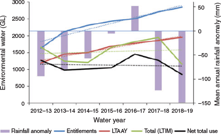
There was no overall change in the volume of environmental flows released between 2012–13 and 2018–19 based on the line of best fit, averaging 1905 GL year–1. A peak of 2820 GL in 2016–17 (Fig. 2a), a wet year, was mostly due to a high volume of water (1250 GL) released down the central Murray, Murrumbidgee and Goulburn rivers from May to December (Table S1), which was followed by a marked decline in releases in 2017–18 and 2018–19. The mean total annual volume is well below the 2750 GL benchmark, the volume intended to be returned to the environment under the Plan (Commonwealth of Australia 2012, p. 43). For Commonwealth and state water released, as well as water from other sources, there was no change in the volume of environmental water released during the first 7 years of the Plan. The pattern of net Commonwealth environmental water releases (mean 1128 GL year–1) is well below the long-term average annual yields for Commonwealth environmental water entitlements, which increased by 722 GL over the 7 years, although the net volume of Commonwealth water released actually declined slightly (based on line of best fit; Fig. 3).
|
There was no correlation between Commonwealth water releases and drought. Mean annual rainfall from 2012–13 and 2018–19 varied between 310 and 514 mm, against a long-term average of 469 mm (1900–2015), with 1 year above average, an average year, 2 years <20% below average and 2 years >25% below average (Fig. 3). The highest and second-highest annual volumes of Commonwealth water were released in the wettest (2016–17) and second driest (2017–18) years respectively, and the lowest was released in the driest year (2018–19), only slightly lower than the volumes delivered in the 2 years of <20% below-average rainfall.
From 2012–13 to 2018–19, a net total of 7893 GL was delivered by CEWO; 59% of the total environmental water from all sources (Fig. 2b). The average amount of all environmental water released in the northern Basin over this period was 11% of the total (all sources) and 7% of total CEWO water. Of total CEWO water, 71% was released down two river valleys: the Murrumbidgee and the Murray. The Goulburn–Broken accounted for a further 11% with the Macquarie–Castlereagh, Gwydir and Lachlan accounting for 2.6, 2 and 1.8% respectively.
The distribution and magnitude of Commonwealth environmental water releases shows a similar pattern annually. For in-channel flows, most water was released in the southern Basin: in the Murray, Murrumbidgee and Goulburn–Broken valleys, accounting for 82% of the total (Fig. 4; Table S1). This pattern relates broadly to the relative magnitude of river discharge (high in the south, lower in the north). The Paroo is an unregulated river and receives no managed environmental water. The Moonie, Border Rivers and Namoi valleys in the north and the Wimmera, Lodden, Campaspe and Ovens in the south contain small areas of important wetlands (Table S2) and received only a small amount of environmental water.

|
Environmental water for floodplain wetlands
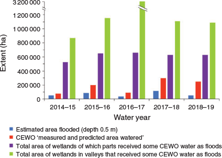
Some 21% of the total volume of Commonwealth environmental water was delivered as overbank and wetland flows (including in-channel flows to terminal wetlands) from 2014–15 to 2018–19, accounting for 1687 GL (Table S5). There were 271 wetland and overbank flood events over the 5 years, of which 247 were in the southern Basin, particularly the lower Murray and lower Murrumbidgee valleys (Fig. 4; see Table S3, which lists 119 wetlands in these valleys from a total of 125). Wetlands in nine of the 19 river valleys we assessed received environmental water as floods (Table 1). The total area of wetlands of which parts thereof received some CEWO water was 687 268 ha, or 21% of the total area of major wetlands in the nine valleys (3 234 367 ha). However, the estimated maximum area flooded (based on a flood of a minimum depth of 0.5 m) over the 5 years was 208 455 ha, giving an average of 41 691 ha year–1 or 23% of the ‘measured and predicted area watered’ by CEWO (182 500-ha annual average), 7% of the area of wetlands of which some parts received some CEWO water (616 420-ha annual average) and 2.6% of the total area of major wetlands in those valleys that received some CEWO water (1 587 031-ha annual average; Fig. 5). The maximum area flooded to 0.5 m over 5 years represents 3.8% of the area of all major wetlands in valleys in the Basin where environmental flows can be delivered, equivalent to 0.8% year–1.

|
|
The consistent pattern over the 5 years was the watering of a large number of very small wetlands with a small volume of water in the lower Murray of South Australia (median area of wetlands 43 ha, median volume of water 125 ML; derived from data in Table S3; cf. also Fig. 4). Of the large Ramsar wetlands, Macquarie Marshes and Gwydir Wetlands received flood events in all years, whereas Narran Lakes received water only in 2016–17 (Hale et al. 2020, table 5 therein), although most of the wetland was inundated in April 2020 (Commonwealth Environmental Water Office 2020b). Only six wetlands in the northern Basin were watered (Western [Toorale] Floodplain, Narran Lakes, Macquarie Marshes, Gwydir and Mallowa Wetlands and Ballin Boora Creek; Table S3). Ramsar wetlands on the Murray and in Victoria received flood events from several water sources, including Commonwealth water, the states and TLM.
The extent of flooding we estimated (Fig. 5) was considerably less than the area of CEWO ‘measured and predicted 1-year outcomes’ (Gawne et al. 2016, p. 30; 2017, p. 33; Hale et al. 2018, p. 36, 2019, p. 31). For example, for 2017–18, Hale et al. (2019) reported over 296 000 ha of wetland and flood plain inundated across the Basin, but the actual volume delivered was sufficient to flood only an estimated 113 886 ha (based on a minimum depth for an ecologically effective flood of 0.5 m). The mean depth of the flooding claimed by Hale et al. (2019) would have been only 19 cm, more where environmental water releases were ‘piggy-backed’ on natural flows but lower if conveyancing losses due to evaporation, evapotranspiration and seepage were taken into account.
Wetland vegetation communities
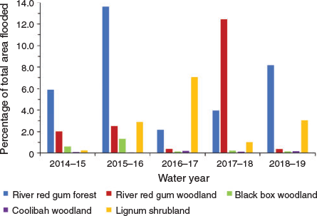
We compared the LTIM-estimated annual flood extent for each vegetation community with expected vegetation outcomes, by river valley, required to meet targets in the Basin-wide EWS (Murray–Darling Basin Authority 2019a, appendix 2 therein). We found significant shortfalls in the extent of flooding achieved to date and the areas stipulated in the expected outcomes for the maintenance of extent and condition of vegetation communities. River red gum forests and woodlands were flooded to the greatest extent (mean 45 210 ha year–1; Table 2). A small proportion of each vegetation community was flooded annually, based on a comparison with the total extent for each vegetation community assessed using the ANAE classification, with a mean of 4.9% of red gum forest, 3.3% of red gum woodland, 0.3% of black box woodland, 0.1% of coolibah woodland and 3% of lignum shrubland (Fig. 6; Table S6).

|
|
Of river red gum forest and woodland, 45 ha in the Border Rivers and 38 ha in the Lower Darling were flooded, though the expected outcomes under the EWS are to maintain the extent and condition of over 10 000 ha in each river valley (Murray–Darling Basin Authority 2019a). River red gum forest and woodland in valleys that received annual or semi-annual flood events (Gwydir, Macquarie-Castlereagh, Lachlan Murrumbidgee and Murray) fared better, with flooding of 18.8% of the total area (258 500 ha) listed in the EWS for these valleys. Only 1.4% of the total area (196 300 ha) of black box woodland listed for the same valleys was flooded (Table 2).
Based on threshold durations of floods for the maintenance of river red gum, black box, coolibah and lignum (Roberts and Marston 2011), we determined a minimum effective duration of ~2 months and maximum of ~7 months (Table S7). Flood duration outside this range was considered suboptimal. Most floods were in the southern Basin (91%) and of short duration, based on a median of 65 days for flow delivery (range 1–396 days; Table S8). From delivery dates only, we estimated 50% of events between 2014–15 and 2018–19 could be considered potentially suboptimal to meet duration requirements for the maintenance of woody wetland vegetation communities, mostly because floods were not long enough and because, for most wetland flood events, water was delivered during the hottest half of the year: 162 events during spring and summer, compared with 60 between autumn and winter (Table 3). Of the volume of environmental water released as overbank flows and wetland flood events, some 962 GL of water for wetland floods was delivered during spring and summer and 594 GL during autumn and winter.

|
Semi-structured interviews
Perceptions of environmental water implementation
All respondents believed that environmental water is important for the conservation of wetland ecosystems in the Basin and has resulted in improved ecosystem condition compared with previous years without environmental water. Nevertheless, respondents hold different views on the implementation of environmental flows. Half thought the Plan is inefficient and insufficient because: (1) successful ecological outcomes are few and quite small; (2) governance arrangements constrain effective watering; (3) water managers work under very constrained circumstances; (4) there was inadequate water availability during initial years (Fed. 3); and (5) irrigation water use is likely to remain over-allocated (Anon. 1). In particular, respondents highlighted the limited control over water releases that water managers have in the northern Basin. Of the respondents who thought the Plan was efficient and sufficient, one believed it was because it is an effective compromise between agriculture and environment (Fed. 1). Others mentioned positive environmental outcomes:
…there’s been very good results, especially in some of the icon sites, especially Barmah-Millewa Forest, watering Moira grass and ecological outcomes there; Gunbower Forest, Hattah Lakes, Lindsay, Mulcra, Wallpolla Wetlands, and environmental water across the South Australian border that helps the Lower Lakes and the Coorong, and all the way out to the sea [Fed. 6].
Respondents agreed there was room for improvement, but did not specify what needed to be improved.
Evaluation of outcomes
In providing examples of successful outcomes, many respondents mentioned in-channel benefits, including aquatic vegetation, fish and in-stream functions. Fish featured strongly (eight respondents), including golden perch spawning in the Goulburn River (Fed. 4), Murray cod breeding in the Darling and Murray (Fed. 3, Fed. 5) and the shepherding of the northern fish flow (Fed. 2; Qld 1). Respondents also mentioned wetland benefits to waterbirds and some specific cases of vegetation outcomes, including red gum forests at Barmah-Millewa, Hattah and Chowilla (Fed. 3, Fed. 5). However, some respondents believed the extent of inundation is inadequate to support wetlands (Fed. 7, Fed. 2, Qld 1). Few floodplain benefits were realised in the northern Basin: two of three respondents who work there thought there were major biophysical, social and institutional constraints to releasing environmental water out of the channel (Fed. 2, Qld 1), including very limited delivery of medium-to-high flows; apart from Macquarie Marshes and Gwydir Wetlands, most environmental water is confined to in-channel flows.
Half the respondents reported that pumping is the main technique to deliver environmental water to targeted sites. One respondent believed pumping can efficiently conserve wetlands as well as prevent the flooding of private properties (Qld 1). Few respondents raised concerns about suboptimal watering events (Fed. 7) and potential water loss from evaporation (Vic. 1). Respondents held positive attitudes about the flooding of wetland vegetation, but they claimed that the Plan is ‘at an early stage’ (even though it is due to be fully operational in 2024) and it is difficult to monitor responses of vegetation to watering. Respondents showed either no understanding or limited appreciation of the actual extent of environmental watering outcomes for wetland vegetation across the Basin.
Constraints on management
Eleven of 13 respondents identified constraints as significant issues impeding environmental watering. These were mainly physical constraints, such as channel capacity and infrastructure, and operational constraints of river regulation, competition with other water users in delivering environmental flows and flooding of private property. Although water users may differ in their seasonal requirements for water releases, government agencies have to make trade-offs, or find synergies, between releasing water for irrigation and the environment (Fed. 2). Concern was expressed that the season of environmental water delivery may not follow the natural life cycle for species to achieve the optimal ecological benefits (Fed. 7, Vic. 1).
Half the respondents mentioned social constraints regarding public acceptance of inundation of flood plains and the risk of economic losses. Political constraints included difficulties in adapting current rules and achieving system-wide outcomes across multiple jurisdictions.
Meeting objectives and targets
There was a divergence of views among the respondents about whether the objectives of the Plan can be met over the long term. Those who thought so focused on the legal requirements for them to do so, despite constraints:
Watering strategy targets aren’t randomly selected, they were developed by the Murray–Darling Basin Authority as a reflection of the amount of water and the constraints in the system. So theoretically we should be able, over decades, to deliver those outcomes, even though you’ve got constraints in the system [Fed. 3].
Several respondents claimed targets were unrealistic because flow regimes are now very different from the past. Half the respondents raised concerns that targets in the Basin-wide watering strategy are too ambitious, described as ‘naïve’, ‘innocent’ and ‘a sign of inexperience’ and ‘perhaps [we] lost sight of what was possible’ (Fed. 7). They also worried about suboptimal events, because many wetlands were not flooded for long enough (Fed. 5), and that targets were set with a limited understanding of the practicalities of real-world water management.
Evaluation of objectives and targets involves defining areas that can be watered, but the amount of water required to protect wetlands cannot be estimated accurately (Qld 1, Fed. 7). It is arguable whether environmental benefits can be achieved simply by watering more areas to achieve targets for particular ecological components. For example:
There are some frogs in this wetland or there’s some water birds here, but the system, in my view, the basin-wide system or the valley-wide ecosystems, their resilience is declining [Fed. 7].
Respondents were unsure whether targets could be met under climate change (Fed. 5, Qld 1). Targets can be met during a wet period but, as dry periods become more frequent, only some wetlands can be maintained.
Discussion
Our review of Commonwealth environmental water delivery found: (1) only 20% of water releases provided flood events to floodplain wetlands and 80% of water was delivered as in-channel flows; (2) an estimated 12% of the wetland area subject to EWS expected outcomes received enough environmental water to constitute an ecologically effective flood, 1% of the area of all major wetlands in the Basin; (3) over 80% of Commonwealth environmental water was delivered to just three river valleys in the southern Basin, which accords with the large water holdings in these valleys (Commonwealth Environmental Water Office 2020c); (4) the extent of flooding of wetland woody vegetation communities is likely to be inadequate to meet their ecological requirements for the maintenance of extent and condition in most cases; and (5) almost 300 GL was delivered during the hottest half of the year, when evaporative loss is highest, thus effectively shortening the duration of flood events.
Environmental water releases
The Plan is two-thirds through its first implementation period, with over A$8.5 billion in public expenditure (Productivity Commission 2018, p. 4), but there is still no official report of whether the 2750 GL of additional environmental water committed to by the Australian Parliament in 2012 has resulted in increased environmental flows in the Basin. Accordingly, there is no objective measure of whether water reform has been successful. Meeting the environmental objectives of the Plan with the limited volume of water available is a complex and difficult task. Accordingly, public reporting of the outcomes in ways that are comprehensive, clear and understandable is a major logistical and communications challenge. In this regard, we acknowledge the new CEWO website (https://flow-mer.org.au/, accessed 17 October 2020), which explains the monitoring, evaluation and research of water use for the environment.
We found no change in the volume of environmental water released between 2012–13 and 2018–19, by either the Commonwealth or the states. This finding appears to reflect the slow progress in accumulation of Commonwealth water holdings during this period. CEWO net total annual releases are well below the long-term average annual yield of Commonwealth entitlements, which showed only a small increase during the first 7 years of the Plan. Water recovery by the Commonwealth has effectively stalled since 2013–14 (Wentworth Group 2017; Grafton et al. 2020, fig. 4 therein). The Wentworth Group (2020) found that despite an estimated 2100 GL of water having been recovered for the environment, between 2012–13 and 2018–19 observed river flows in the Basin were markedly lower than expected, even after accounting for dry conditions. This finding indicates there has been no improvement, or even declines, in flows since the Plan was implemented. Environmental flow targets set by the MDBA have not been achieved. The standard response from government agencies to such findings is that the Plan is not due to be implemented in full until 2024 and it would be entirely expected that the objectives would not yet be fully achieved. This position beggars the question of how the substantial shortfall in environmental water delivery, well below the statutory baseline of 2750 GL year–1, will be achieved in the remaining one-third of the implementation period when there has been no increase in the previous two-thirds. It also ignores the setting of flow targets as indicators of progress towards outcomes by the MDBA.
Losses of surface water from evaporation, transpiration and seepage to groundwater during the conveyance of flows from headwater dams to sites of end use appear to have increased (Murray–Darling Basin Authority 2019c, fig. 7 therein), accounting for 620 GL in conveyance loss for the River Murray in 2018–19 (1 June 2018–31 January 2019), the second hottest year on record after 2019–20. Conveyance losses were accounted for in the Plan as part of river operations and are not attributed to environmental water holder accounts. However, losses will continue to increase under a drying climate, reducing the proportion of environmental flows that reaches wetlands and requiring a greater volume of water recovery to meet the environmental objectives of the Plan.
Environmental water for floodplain wetlands
Environmental flows were never intended to support the total area of wetlands in the Basin. Indeed, the Plan states:
The fact that water storages and properties (including floodplains) are under the control of various persons currently restricts the capacity to actively manage all water-dependent ecosystems [Commonwealth of Australia 2012, p. 56].
However, we found the volume of environmental water used to flood wetlands was unlikely to meet the requirements for priority areas identified in the Basin-wide EWS. Although major wetlands, including Ramsar wetlands, have received some environmental water as floods, most flood events have been small volumes of water delivered to small wetlands, mostly in the lower Murray and Murrumbidgee river valleys. There is simply not enough environmental water available to achieve the environmental objectives of the Murray–Darling Basin Plan. The Guide to the Proposed Basin Plan (Murray–Darling Basin Authority 2010a, p. 68, 2010b) estimated 3000–7600 GL to protect and restore water-dependent ecosystems in the Basin. The amount finally determined was 2750 GL year–1, widely considered to be much less than required (e.g. Prosser et al. 2012, pp. 88, 89; Walker 2019, pp. 53, 56, 383; Grafton et al. 2020, p. 5). However, the annual mean total volume released between 2012–13 and 2018–19 was only 1905 GL (Fig. 2). Although there is scope for improving the efficacy of the limited environmental water available (e.g. by releasing it at times of year when transmission losses are low and when flooding might occur naturally), the amount needed is likely to be considerably higher than 2750 GL.
In many wetlands in the lower Murray, flooding can only be achieved by pumping because wetlands are cut off from the main channel, requiring very high in-channel flows before flooding commences (Jensen 2016; Wentworth Group 2017). The extent of flooding achieved in the Macquarie and Gwydir valleys is likely to be insufficient to maintain ecological condition of the entire wetland: monitoring of the Gwydir Wetlands found a decline in plant species richness driven by inadequate inundation (Murray–Darling Basin Authority 2018c). These large wetlands contain much smaller Ramsar sites (entire Macquarie Marshes, 200 000 ha; Ramsar site, 19 850 ha; Gwydir Wetlands system, 102 120 ha; Gingham and Lower Gwydir Watercourses Ramsar site, 823 ha), which received environmental water as a priority in every year between 2014–15 and 2018–19, but water was not available for the entire wetlands. Some 11 of the 13 Ramsar sites within the area of managed flood plain in the Basin were watered during the 5 years, indicating their priority status for watering (Hale et al. 2020, p. 40).
Wetlands in nine of the 19 river valleys we assessed received floods with Commonwealth water (Table 1), even though 15 of them have objectives and outcomes listed in the Basin-wide EWS that require flooding in order to be met (Murray–Darling Basin Authority 2019a, appendix 2 therein). It could be assumed that water from other sources may be making up some of the shortfall. However, most water from the states and other sources delivered flood events in the same river valleys that were targeted by the Commonwealth (Table S1).
Understandably, Commonwealth water delivered as flood events, either by overbank flows or pumping, has tended to be in river valleys where it is relatively easy to do so, using releases from large headwater dams, infrastructure to connect channels to wetlands and partnerships with environmental water managers, non-governmental organisations and landholders (e.g. Nias 2005; Jensen 2016). In other valleys, particularly in the northern Basin, operational delivery is constrained by a lack of public storages, rules that allow irrigators to legally divert environmental water (Wentworth Group 2017, p. 56) and illegal diversions (Wheeler et al. 2020).
Some 79% of Commonwealth water was delivered as in-channel flows (Table S5) and provided for important ecological benefits (e.g. Hale et al. 2020, pp. 5, 6). However, a lack of lateral connectivity between channels and wetlands represents a major opportunity cost to the protection and restoration of ecosystem functions by limiting the transfer of allochthonous carbon, nutrients and energy sources from the flood plain to the river channel (Baldwin et al. 2016; Mitrovic and Baldwin 2016; Rees et al. 2020). The 2018–19 annual watering priorities included, for the first time, the objective of improvement of flows from the channel out to the floodplain (Murray–Darling Basin Authority 2018a, p. 11).
Operational constraints on water delivery in the River Murray as part of the ‘good neighbour policy’ (whereby flooding of private land is avoided) limit maximum planned regulated flows to 15 000 ML day–1 downstream of Yarrawonga Weir (Murray–Darling Basin, Basin Officials Committee 2019, p. 21). In turn, this constraint limits environmental watering of the Millewa Forest to flood depths of ~0.3 m (P. Childs, pers. comm.). Not enough water can be put down the river under current rules to meet environmental requirements.
Wetland vegetation communities
One of the limitations of assessing the extent of flood events for major vegetation communities that are subject to expected outcomes under the Basin-wide EWS relates to how communities are categorised. The interim ANAE classification includes types that are likely to contain river red gum forest and woodland, black box and coolibah woodland and lignum shrubland, but this is not apparent from the title of each type (e.g. ‘temporary woodland swamp’, ‘woodland riparian zone or floodplain’ and ‘temporary shrub swamp’) and type descriptions do not include details of woody species (Brooks et al. 2014). Accordingly, the areas of the wetland woody vegetation communities we use are likely to be underestimates.
An annual average of 1.7% of the total area of wetland woody vegetation that is subject to expected outcomes under the Plan received environmental water as floods over the 5-year period (Table S6). The duration of half of the flood events was likely to have been suboptimal to achieve water requirements for the maintenance for these communities (Table 3; Table S8). Regarding the frequency of flood events, of the 125 wetlands assessed, 58 (46%) received floods with a frequency of 1 year in 5 (Table S3), which may just be sufficient to maintain river red gum forest and woodland (Doody et al. 2015), although Roberts and Marston (2011) determined that the frequency of flooding required to maintain river red gum forest and woodland is 1 in 3 years and 1 in 4 years respectively (Table S7). Adopting a planning framework that directly relates flooding frequency to the requirements of species of wetland woody vegetation could help improve environmental watering for these communities (Overton et al. 2011).
We acknowledge the limitations of our assessment of flood duration because we were not able to quantify how long water remained in wetlands after delivery of water had ceased (i.e. the period of the falling limb of the flood hydrograph). Season is important in this respect: floods delivered in the cooler months will have a substantially longer duration than those delivered in summer (Roberts and Marston 2011, p. 43). Yet, 67% flood events, predominantly in the southern Basin (where 91% of events occurred), were delivered during late spring and summer, the hottest half of the year (Table 3; Fig. S1), in part because environmental flows can be ‘piggy-backed’ onto high in-channel summer flows released for irrigation, particularly in the Murray and Murrumbidgee. River heights are much lower in late Winter and early Spring, which historically was the period of high natural flows and floods in the rivers of the southern Basin (CSIRO 2008, p. 54). From estimated mean daily evaporation for the Basin (based on pan evaporation rates at 10 meteorological stations; Fig. 1, S1), it would take 50 days to completely draw down a flood of 0.5 m in depth delivered in January (daily rate 10.1 mm day–1), less accounting for wind speed. Within 30 days of water delivery to a wetland during December and January, 61% would be lost to evaporation, compared with 13% during June and July, when the daily rate of evaporation is nearly five times lower (2.1 mm day–1). Because of evaporative loss, floods delivered to woody vegetation communities between late spring and mid-autumn are less likely to persist long enough to meet the ecological requirements of those communities than floods delivered from late autumn to mid-spring.
It is important to note that in several cases expected outcomes in the EWS specify the maintenance of the extent and condition of communities ‘on low-lying areas of the floodplain’ (Murray–Darling Basin Authority 2019a, appendix 2 therein). Such objectives are likely to benefit river red gum communities, which tend to be located on lower flood plains. But black box woodland, which has the largest extent subject to objectives under the Plan, is located on upper flood plains (Roberts and Marston 2011), often requiring very large in-channel flows before flooding commences, hence the use of pumping to maintain black box communities on the South Australian Murray (Jensen 2016). It is questionable whether this approach is sustainable in the long term. Black box woodland is the most vulnerable wetland woody vegetation community to not receive the water it requires to maintain extent and condition.
Significant uncertainty remains over the capacity to maintain the extent and condition of vegetation communities under the Plan. Many objectives for floodplain and wetland trees and shrubs were reported as ‘not met’ or only ‘partially met’ (which is effectively the same as ‘not met’) at Living Murray icon sites between 2012–13 and 2016–17 (Murray–Darling Basin Authority 2018b, p. 16).
Semistructured interviews
Our review of interview responses found that: (1) there was high uncertainty over whether environmental water releases can provide the desired environmental benefits; (2) constraints on management are a major determinant of environmental water performance; and (3) many environmental targets are unrealistic because they are not backed by ecological knowledge to support implementation (Fed. 5; King et al. 2015).
Evaluation of effectiveness
Water delivery by pumping has been regarded as a pragmatic method of watering wetlands that are cut off from their main channel. Half the respondents recognised pumping as a major effective technique to deliver water. However, pumping can have adverse ecological outcomes (Fed. 7; Pittock et al. 2013; Vilizzi et al. 2013), including increased mortality of fishes (Bond et al. 2014). Pumping water to wetlands creates only ‘one-way’ connectivity, with no return pathway for dispersal of biota (Vilizzi et al. 2013). Environmental water delivered by pumps and sprinklers involves small volumes and restricted areas (Bond et al. 2014). Such artificial watering cannot replicate managed floods or natural conditions or natural water requirements for woody vegetation. It is questionable whether such an approach is sustainable in the long term.
Challenges and opportunities
Water management was not considered by several respondents to have achieved the best use of environmental water. Constraints included a lack of knowledge of ecological responses to support decision making and best practice guidelines (Colloff et al. 2018; Reid and Brooks 2000). Although the use of ‘best available science’ is mandatory under the Water Act, our findings from the interviews indicate that knowledge from research is rarely used to effectively support operational decision making, such as when an environmental water release is likely to result in suboptimal outcomes. In this context, adaptive management and learning by doing provides an important support for decision making, but has often been done badly.
Water management in the Basin involves a complex mix of multiple jurisdictions and agencies, governance arrangements, rules and public and private stakeholders, with all the attendant conflicts and contestation of interests and world views that this complexity engenders (Colloff and Pittock 2019; Grafton et al. 2020). Constraints on operating rules to avoid flooding of private land limit the delivery of large environmental flows (Qld 1). The Constraints Management Strategy is aimed at addressing these issues to improve environmental outcomes in the long term (Murray–Darling Basin Authority 2013, p. 5). Negotiating flood easements on private land can be challenging, but is achievable if convergence of interests and benefits derived from environment watering receives widespread community support (Lukasiewicz and Dare 2016) and compelling cases can be made for widespread private and public good benefits (Kahan et al. 2020).
Issues of environmental water reporting and accounting
Claims of success
Reporting of ecological benefits from environmental watering have been exaggerated in some cases. In the 5-year review of the Plan, the Productivity Commission (2018, p. 267) stated:
Over 750 environmental watering events have occurred over the past five years… The environment is responding positively to environmental watering activities with early evidence of improved ecological outcomes at the local and system scale.
However, no evidence was provided to support the claim of environmental improvement. Other authors have made similar statements. Webb et al. (2018) considered the benefits of the Plan ‘are slowly but surely being seen’. Stewardson and Guarino (2018), based on a single year of data (2014–15), claimed CEWO watering program ‘provides a successful example of implementing a basin-scale program for environmental water delivery’. These perspectives are not supported by our findings.
Areas of influence
There is concern about the use of the concept of ‘areas influenced’ by Commonwealth environmental water in the reporting of areas inundated. The area influenced ‘acknowledges that aquatic ecosystems are complex interconnected systems and delivering water to part of a wetland contributes benefits to the entire wetland system’ (Hale et al. 2019). The hydrological evidence for this claim is tenuous at best and direct benefits from water are likely to be highly context specific. For example, regular flooding of the low-lying flood plain does not provide water to trees that are flooded less regularly at higher elevations without substantial lateral recharge of soil water, which is site dependent (Doody et al. 2015). On Chowilla Floodplain, river red gum trees at distances >15 m from creeks used no creek water, due to lack of lateral hydrological connectivity (Mensforth et al. 1994). There is a real risk of overstating the benefits of environmental watering by using ‘areas influenced’ in order to make the numbers look better than they would by reporting the actual areas flooded. Such an approach could lead to assumptions of benefits from environmental watering when the on-ground reality is that watering has been suboptimal.
A question of attribution
Stewardson and Guarino (2017, p. 7) state that attributing flooding events to Commonwealth environmental water, rather than other sources, is difficult because ‘the information required for attribution was not easily accessible and on-ground validation was not comprehensive’. Floods attributed to Commonwealth water may include ‘contributions from other environmental water and other water. As such, inundation area linked to Commonwealth environmental water has been classed with low confidence’. This issue raises concerns that the extent of inundation claimed as due to CEWO water may be greater than in reality.
Shifting boundaries
The boundaries of river valleys used for environmental water accounting have changed over time. CEWO has used several versions and the current one (e.g. Brooks 2019, p. 7) is different from that used by Murray–Darling Basin Authority (2020). Inexplicably, CEWO place the Lachlan valley in the northern Basin, whereas the MDBA considers it part of the southern Basin. These inconsistencies increase the complexity and uncertainty of environmental water accounting and standardised reporting approaches are needed.
Adaptive management
The Plan has regularly been claimed as an example of adaptive management in practice (Murray–Darling Basin Authority 2017; Watts et al. 2020; Gawne et al. 2020). However, the current Basin-scale monitoring and evaluation program is limited in extent and lacks an ecologically defensible methodology for upscaling to whole-of-Basin reporting. Current efforts are an amalgam of area-based monitoring and evaluation (Thompson et al. 2019; Gawne et al. 2020), rendered more complex by separate reporting by multiple jurisdictions.
While processes for adaptive management have been implemented for at least one specific project (Conallin et al. 2018), as far as we are aware there are no governance arrangements in place that would allow water managers, scientists and policy decision makers to share findings and lessons learned, at Basin-scale, in a coproductive way. Without such processes, and a unified, coordinated reporting approach between the Commonwealth and states, it is difficult to see how claims can be substantiated for a truly strategic adaptive management process, as first used for environmental monitoring in South African National Parks (Roux and Foxcroft 2011). Using such an approach would be a significant step forward. Further, if there is the perception that monitoring is not being synthesised and used, and lessons learned are being acted upon by those responsible for the Plan, it is understandable that there have been calls for greater transparency and independent auditing (e.g. Grafton et al. 2020) to ensure the assessment of benefits of environmental flows can be trusted by the public.
Operational limits and ‘triage by default’
We found the area of wetlands that received water as floods more than 1 year in 5 (the minimum required to maintain most woody vegetation communities) represents 49% of wetland area that received some CEWO water as floods, 16% of wetland area that can be watered regularly, 10% of wetlands in valleys that received some water as floods and 5% of the area within the managed floodplain (i.e. within scope for EWS expected outcomes; Fig. 7). The marked difference between the area within scope for expected outcomes under the Plan and what was actually achieved in 5 years indicates a process of what we refer to as ‘triage by default’, whereby only smaller wetlands and a fraction of the lower-lying parts of large wetlands can be flooded with a frequency to maintain their extent and condition. Operational limits on water availability, delivery and other constraints, including the restricted capacity to actively manage wetlands on private land, have resulted in a shortfall between Basin environmental watering priorities and what can be achieved in reality. This situation is only likely to worsen under an increasingly hotter and dryer climate.

|
Under circumstances where triage by default has become a reality, decisions about how and where wetlands and their constituent species and populations can be conserved depend on societal and held human values, as well as science-based prioritisation processes (Wiens and Hobbs 2015). Deliberations about which wetlands can be maintained and which will inevitably transition to dryland ecosystems will be fundamental to the reframing of environmental water policy and planning under climate change and the increasing demand for ever-scarcer water resources.
Concluding remarks
In summary, our evaluation of environmental watering indicated limited outcomes for environmental water delivery to achieve wetland conservation across the Basin. Environmental water delivery has not supported floods of the magnitude, duration and extent required to maintain or improve the condition of wetlands and their woody vegetation communities. Constraints on water management and planning have resulted in institutional failures in achieving effective and efficient use of environmental water, including the timing of water delivery to avoid significant losses to evaporation. Without significant changes in approach, including a fundamental rethink of what objectives are practical and achievable under climate change, it is likely that environmental watering will fail to protect more than a minority of Basin wetlands into the future. Because the Murray–Darling Basin Plan claims to use an adaptive management framework, there are clear opportunities to use best practices from this approach to greatly improve implementation.
Conflicts of interest
Jamie Pittock is a member and Matt Colloff an associate of the Wentworth Group of Concerned Scientists. The authors declare that they have no other conflicts of interest.
Declaration of funding
The authors received no specific funding for this research.
Acknowledgements
We thank the staff from federal and state agencies who donated their time and provided valuable insights during interviews, as well as those who answered questions by email and provided data. We thank staff of the Murray–Darling Basin Authority, the Commonwealth Environmental Water Office and members of the Long-term Intervention Monitoring Project team for their constructive comments on an earlier draft of this paper. We are grateful to Paul Childs and Keith Ward for discussions on operational constraints and advice on the minimum depth for an ecologically effective flood.
References
Australian Bureau of Statistics, Australian Bureau of Agricultural and Resource Economics, and Bureau of Rural Sciences (2009). Socio-economic context for the Murray–Darling Basin. (Murray–Darling Basin Authority: Canberra, ACT, Australia.)Baldwin, D. S., Colloff, M. J., Mitrovic, S. M., Bond, N. R., and Wolfenden, B. (2016). Restoring dissolved organic carbon subsidies from floodplains to lowland river food webs: a role for environmental flows? Marine and Freshwater Research 67, 1387–1399.
| Restoring dissolved organic carbon subsidies from floodplains to lowland river food webs: a role for environmental flows?Crossref | GoogleScholarGoogle Scholar |
Biernacki, P., and Waldorf, D. (1981). Snowball sampling: problems and techniques of chain referral sampling. Sociological Methods & Research 10, 141–163.
| Snowball sampling: problems and techniques of chain referral sampling.Crossref | GoogleScholarGoogle Scholar |
Bond, N., Costelloe, J., King, A., Warfe, D., Reich, P., and Balcombe, S. (2014). Ecological risks and opportunities from engineered artificial flooding as a means of achieving environmental flow objectives. Frontiers in Ecology and the Environment 12, 386–394.
| Ecological risks and opportunities from engineered artificial flooding as a means of achieving environmental flow objectives.Crossref | GoogleScholarGoogle Scholar |
Bowen, S., and Simpson, S. L. (2009). Changes in extent and condition of the vegetation communities of the Gwydir Wetlands and floodplain 1996–2008. New South Wales Department of Environment, Climate Change and Water, Sydney, NSW, Australia.
Bowen, S., and Simpson, S. L. (2010). Changes in extent and condition of the vegetation communities of the Macquarie Marshes floodplain 1991–2008. New South Wales Department of Environment, Climate Change and Water, Sydney, NSW, Australia.
Braun, V., and Clarke, V. (2006). Using thematic analysis in psychology. Qualitative Research in Psychology 3, 77–101.
| Using thematic analysis in psychology.Crossref | GoogleScholarGoogle Scholar |
Brooks, S. (2016). 2014–15 Basin-scale evaluation of Commonwealth environmental water – ecosystem diversity. Murray–Darling Freshwater Research Centre, Wodonga, Vic., Australia.
Brooks, S. (2017). 2015–16 Basin-scale evaluation of Commonwealth environmental water – ecosystem diversity. Murray–Darling Freshwater Research Centre, Wodonga, Vic., Australia.
Brooks, S. (2018). 2016–17 Basin-scale evaluation of Commonwealth environmental water – ecosystem diversity. Murray–Darling Freshwater Research Centre, Wodonga, Vic., Australia.
Brooks, S. (2019). 2017–18 Basin-scale evaluation of Commonwealth environmental water – ecosystem diversity. Murray–Darling Freshwater Research Centre, Wodonga, Vic., Australia.
Brooks, S. (2020). 2018–19 Basin-scale evaluation of Commonwealth environmental water – ecosystem diversity. Murray–Darling Freshwater Research Centre, Wodonga, Vic., Australia.
Brooks, S., Cottingham, P., Butcher, R., and Hale, J. (2014). Murray–Darling Basin aquatic ecosystem classification: stage 2 report. Peter Cottingham & Associates, Melbourne, Vic., Australia.
Butcher, R., Hale, J., Capon, S., and Thoms, M. (2011). Ecological character description for Narran Lake Nature Reserve. Department of Sustainability, Environment, Water, Population and Communities, Canberra, ACT, Australia.
Cai, W., and Cowan, T. (2008). Evidence of impacts from rising temperature on inflows to the Murray–Darling Basin. Geophysical Research Letters 35, L07701.
| Evidence of impacts from rising temperature on inflows to the Murray–Darling Basin.Crossref | GoogleScholarGoogle Scholar |
Capon, S., and Campbell, C. (2017). 2015–16 Basin-scale evaluation of Commonwealth environmental water – vegetation diversity. Murray–Darling Freshwater Research Centre, Wodonga, Vic., Australia.
Chiew, F. H. S., Teng, J., Kirono, D., Frost, A. J., Bathois, J. M., Vaze, J., Viney, N. R., Young, W. J., Hennessy, K. J., and Cai, W. J. (2008). Climate data for hydrologic scenario modelling across the Murray–Darling Basin. A report to the Australian Government from the CSIRO Murray–Darling Basin Sustainable Yields Project. CSIRO, Canberra, ACT, Australia.
Colloff, M. J. (2014). ‘Flooded Forest and Desert Creek: Ecology and History of the River Red Gum.’ (CSIRO Publishing: Melbourne, Vic., Australia.)
Colloff, M. J., and Pittock, J. (2019). Why we disagree about the Murray–Darling Basin Plan: water reform, environmental knowledge and the science-policy decision context. Australasian Journal of Water Resources 23, 88–98.
| Why we disagree about the Murray–Darling Basin Plan: water reform, environmental knowledge and the science-policy decision context.Crossref | GoogleScholarGoogle Scholar |
Colloff, M. J., Caley, P., Saintilan, N., Pollino, C. A., and Crossman, N. C. (2015). Long-term ecological trends of flow-dependent ecosystems in a major river basin. Marine and Freshwater Research 66, 957–969.
| Long-term ecological trends of flow-dependent ecosystems in a major river basin.Crossref | GoogleScholarGoogle Scholar |
Colloff, M. J., Overton, I. C., Henderson, B., Roberts, J., Reid, J. R. W., Oliver, R. L., Arthur, A. D., Doody, T. M., Sims, N. C., Ye, Q., and Cuddy, S. M. (2018). The use of historical environmental monitoring data to test predictions on cross-scale ecological responses to alterations in river flows. Aquatic Ecology 52, 133–153.
| The use of historical environmental monitoring data to test predictions on cross-scale ecological responses to alterations in river flows.Crossref | GoogleScholarGoogle Scholar |
Commonwealth Environmental Water Office (2013). Framework for determining Commonwealth environmental water use. Commonwealth Environmental Water Office, Canberra, ACT, Australia.
Commonwealth Environmental Water Office (2020a). Water use in catchments. Commonwealth Environmental Water Office, Canberra, ACT, Australia. Available at http://www.environment.gov.au/water/cewo/catchment [Verified 6 May 2020].
Commonwealth Environmental Water Office (2020b). Lower Balonne flow 2020 – update #4. Commonwealth Environmental Water Office, Canberra, ACT, Australia. Available at https://www.environment.gov.au/water/cewo/publications/lower-balonne-flow-2020-update-4 [Verified 22 August 2020].
Commonwealth Environmental Water Office (2020c) Commonwealth environmental water holdings by catchment and year. Commonwealth Environmental Water Office, Canberra, ACT, Australia. Available at https://www.environment.gov.au/water/cewo/about/water-holdings [Verified 18 October 2020].
Commonwealth of Australia (2012). Water Act 2007 Basin Plan. Available at https://www.legislation.gov.au/Details/F2020C00074 [Verified 8 November 2020].
Conallin, J., Campbell, J., and Baumgartner, L. (2018). Using strategic adaptive management to facilitate implementation of environmental flow programs in complex social-ecological systems. Environmental Management 62, 955–967.
| Using strategic adaptive management to facilitate implementation of environmental flow programs in complex social-ecological systems.Crossref | GoogleScholarGoogle Scholar | 30145699PubMed |
Connell, D., and Grafton, R. Q. (2011). Water reform in the Murray–Darling Basin. Water Resources Research 47, W00G03–9.
| Water reform in the Murray–Darling Basin.Crossref | GoogleScholarGoogle Scholar |
CSIRO (2008). Water Availability in the Murray–Darling Basin. A report to the Australian Government from the CSIRO Murray–Darling Basin Sustainable Yields Project. CSIRO, Canberra, ACT, Australia.
Davies, P., Harris, J., Hillman, T., and Walker, K. (2010). The sustainable rivers audit: assessing river ecosystem health in the Murray–Darling Basin, Australia. Marine and Freshwater Research 61, 764–777.
| The sustainable rivers audit: assessing river ecosystem health in the Murray–Darling Basin, Australia.Crossref | GoogleScholarGoogle Scholar |
Davies, P. E., Stewardson, M. J., Hillman, T. J., Roberts, J. R., and Thoms, M. C. (2012). Sustainable Rivers Audit 2: the ecological health of rivers in the Murray–Darling Basin at the end of the Millennium Drought (2008–2010). Volume 1. Murray–Darling Basin Commission, Canberra, ACT, Australia.
Department of Agriculture, Water and the Environment (2020). Managing water for the environment. Available at https://www.environment.gov.au/water/cewo/about-commonwealth-environmental-water [Verified 7 May 2020].
Department of Environment, Water and Natural Resources (2017). South Australia’s River Murray environmental watering report 2016–17. DEWNR, Adelaide, SA, Australia.
Docker, B., and Robinson, I. (2014). Environmental water management in Australia: experience from the Murray–Darling Basin. International Journal of Water Resources Development 30, 164–177.
| Environmental water management in Australia: experience from the Murray–Darling Basin.Crossref | GoogleScholarGoogle Scholar |
Doody, T. M., Colloff, M. J., Davies, M., Koul, V., Benyon, R. G., and Nagler, P. L. (2015). Quantifying water requirements of riparian river red gum (Eucalyptus camaldulensis) in the Murray–Darling Basin, Australia – implications for environmental water allocations. Ecohydrology 8, 1471–1487.
| Quantifying water requirements of riparian river red gum (Eucalyptus camaldulensis) in the Murray–Darling Basin, Australia – implications for environmental water allocations.Crossref | GoogleScholarGoogle Scholar |
Drever, E. (1995). ‘Using Semi-structured Interviews in Small-scale Research: A Teacher’s Guide.’ (Scottish Council for Research in Education: Glasgow, UK.)
Environment Australia (2001). ‘A Directory of Important Wetlands in Australia’, 3rd edn. (Environment Australia: Canberra, ACT, Australia.)
Gawne, B., Hale, J., Brooks, S., Campbell, C., Capon, S., Everingham, P., Grace, M., Guarino, F., Stoffels, R., and Stewardson, M. (2016). 2014–15 Basin-scale evaluation of Commonwealth environmental water – synthesis report. Murray–Darling Freshwater Research Centre, Wodonga, Vic., Australia.
Gawne, B., Hale, J., Brooks, S., Campbell, C., Capon, S., Everingham, P., Grace, M., Guarino, F., Stoffels, R., and Stewardson, M. (2017). 2015–16 Basin-scale evaluation of Commonwealth environmental water – synthesis report. Murray–Darling Freshwater Research Centre, Wodonga, Vic., Australia.
Gawne, B., Hale, J., Stewardson, M. J., Webb, J. A., Ryder, D. S., Brooks, S. S., Campbell, C. J., Capon, S. J., Everingham, P., and Grace, M. R. (2020). Monitoring of environmental flow outcomes in a large river basin: the Commonwealth Environmental Water Holder’s long-term intervention in the Murray–Darling Basin, Australia. River Research and Applications 36, 630–644.
| Monitoring of environmental flow outcomes in a large river basin: the Commonwealth Environmental Water Holder’s long-term intervention in the Murray–Darling Basin, Australia.Crossref | GoogleScholarGoogle Scholar |
Grafton, R. Q. (2019). Policy review of water reform in the Murray–Darling Basin, Australia: the ‘do’s’ and ‘do nots’. The Australian Journal of Agricultural and Resource Economics 63, 116–141.
| Policy review of water reform in the Murray–Darling Basin, Australia: the ‘do’s’ and ‘do nots’.Crossref | GoogleScholarGoogle Scholar |
Grafton, R. Q., Colloff, M. J., Marshall, V., and Williams, J. (2020). Confronting a ‘post-truth water world’: facts versus fiction in the Murray–Darling Basin, Australia. Water Alternatives 13, 1–28.
Hale, J., Bond, N., Brooks, S., Capon, S., Grace, M., Guarino, F., Mynott, J., Stoffels, R., Stewardson, M., and Thurgate, N. (2018). 2016–17 Basin-scale evaluation of Commonwealth environmental water – synthesis report. La Trobe University, Wodonga, Vic., Australia.
Hale, J., Bond, N., Brooks, S., Campbell, C., Capon, S., Grace, M., Guarino, F., King, A., Mynott, J., Stewardson, M., and Thurgate, N. (2019). 2017–18 Basin-scale evaluation of Commonwealth environmental water – synthesis report. La Trobe University, Wodonga, Vic., Australia.
Hale, J., Bond, N., Brooks, S., Capon, S., Grace, M., Guarino, F., James, C., King, A., McPhan, L., Mynott, J., Stewardson, M., and Thurgate, N. (2020). 2018–19 Basin-scale evaluation of Commonwealth environmental water – synthesis report. La Trobe University, Wodonga, Vic., Australia.
Harwell, M. R. (2011). Research design in qualitative/quantitative/mixed methods. In ‘The Sage Handbook for Research in Education’. (Eds C. F. Conrad and R. C. Serlin.) pp. 147–164. (Sage Publications: Los Angeles, CA, USA.)
Jensen, A. (2016). Delivery of environmental water by Water For Nature Program in the South Australian River Murray Valley 2013–16. Available at https://www.naturefoundation.org.au/publications/fact-sheets/wfn-monitoring-report-2013-16-ver8.pdf [Verified 4 May 2020].
Kahan, G., Pittock, J., and Colloff, M. J. (2020). Using an ecosystem services approach to re-frame the management of flow constraints in a major regulated river basin. Australasian Journal of Water Resources. , .
| Using an ecosystem services approach to re-frame the management of flow constraints in a major regulated river basin.Crossref | GoogleScholarGoogle Scholar |
King, A. J., Gawne, B., Beesley, L., Koehn, J. D., Nielsen, D. L., and Price, A. (2015). Improving ecological response monitoring of environmental flows. Environmental Management 55, 991–1005.
| Improving ecological response monitoring of environmental flows.Crossref | GoogleScholarGoogle Scholar | 25835945PubMed |
Kingsford, R. T. (2000). Ecological impacts of dams, water diversions and river management on floodplain wetlands in Australia. Austral Ecology 25, 109–127.
| Ecological impacts of dams, water diversions and river management on floodplain wetlands in Australia.Crossref | GoogleScholarGoogle Scholar |
Lindenmayer, D. B., and Likens, G. E. (2018). ‘Effective Ecological Monitoring’, 2nd edn. (CSIRO Publishing: Melbourne, Vic., Australia.)
Lukasiewicz, A., and Dare, M. L. (2016). When private water rights become a public asset: stakeholder perspectives on the fairness of environmental water management. Journal of Hydrology 536, 183–191.
| When private water rights become a public asset: stakeholder perspectives on the fairness of environmental water management.Crossref | GoogleScholarGoogle Scholar |
Mensforth, L. J., Thorburn, P. J., Tyerman, S. D., and Walker, G. R. (1994). Sources of water used by riparian Eucalyptus camaldulensis overlying highly saline groundwater. Oecologia 100, 21–28.
| Sources of water used by riparian Eucalyptus camaldulensis overlying highly saline groundwater.Crossref | GoogleScholarGoogle Scholar | 28307023PubMed |
Mitrovic, S. M., and Baldwin, D. S. (2016). Allochthonous dissolved organic carbon in river, lake and coastal systems: transport, function and ecological role. Marine and Freshwater Research 67, i–iv.
| Allochthonous dissolved organic carbon in river, lake and coastal systems: transport, function and ecological role.Crossref | GoogleScholarGoogle Scholar |
Moxham, C., Kenny, S. A., Beesley, L. S., and Gwinn, D. C. (2019). Large-scale environmental flow results in mixed outcomes with short-term benefits for a semi-arid floodplain plant community. Freshwater Biology 64, 24–36.
| Large-scale environmental flow results in mixed outcomes with short-term benefits for a semi-arid floodplain plant community.Crossref | GoogleScholarGoogle Scholar |
Murray–Darling Basin Authority (2010a). Guide to the proposed Basin Plan: overview. MDBA, Canberra, ACT, Australia.
Murray–Darling Basin Authority (2010b). Guide to the proposed Basin Plan: technical background. Part II. MDBA, Canberra, ACT, Australia.
Murray–Darling Basin Authority (2011). The Living Murray story: one of Australia’s largest river restoration projects. MDBA, Canberra, ACT, Australia.
Murray–Darling Basin Authority (2012a). Hydrologic modelling to inform the proposed Basin Plan: methods and results. MDBA, Canberra, ACT, Australia.
Murray–Darling Basin Authority (2012b). Barmah–Millewa Forest environmental water management plan. MDBA, Canberra, ACT, Australia.
Murray–Darling Basin Authority (2012c). Assessment of environmental water requirements for the proposed Basin Plan: Lachlan Swamp. MDBA, Canberra, ACT, Australia.
Murray–Darling Basin Authority (2013). Constraints management strategy 2013 to 2024. MDBA, Canberra, ACT, Australia.
Murray–Darling Basin Authority (2017). Basin Plan adaptive management framework: 2017 basin plan evaluation. MDBA, Canberra, ACT, Australia.
Murray–Darling Basin Authority (2018a). Basin environmental watering priorities. Overview and technical summaries. MDBA, Canberra, ACT, Australia.
Murray–Darling Basin Authority (2018b). Icon site condition: the Living Murray. MDBA, Canberra, ACT, Australia.
Murray–Darling Basin Authority (2018c). Basin environmental watering outlook for 2018–19. MDBA, Canberra, ACT, Australia.
Murray–Darling Basin Authority (2019a). ‘Basin-Wide Environmental Watering Strategy’, 2nd edn. (MDBA: Canberra, ACT, Australia.)
Murray–Darling Basin Authority (2019b). Climate change and the Murray–Darling Basin Plan. MDBA, Canberra, ACT, Australia.
Murray–Darling Basin Authority (2019c). Losses in the River Murray system 2018–19. MDBA, Canberra, ACT, Australia.
Murray–Darling Basin Authority (2020). Catchments in the Murray–Darling Basin. (MDBA: Canberra, ACT, Australia.) Available at https://www.mdba.gov.au/discover-basin/catchments [Verified 12 May 2020]
Murray–Darling Basin, Basin Officials Committee (2019). Objectives and outcomes for river operations in the River Murray System. Murray–Darling Basin Authority, Canberra, ACT, Australia.
National Water Commission (2004). Intergovernmental agreement on a national water initiative. (National Water Commission: Canberra, ACT, Australia.) Available at https://www.pc.gov.au/inquiries/completed/water-reform/national-water-initiative-agreement-2004.pdf [Verified 3 May 2020].
Nias, D. (2005). Adaptive environmental water in the Murray Valley, NSW 2000–2003. New South Wales Murray Wetlands Working Group, Albury, NSW, Australia.
NSW Department of Planning, Industry and Environment (2019). Barwon–Darling long term water plan Part A. NSW DPIE, Sydney, NSW, Australia.
NSW Office of Environment and Heritage (2012). Macquarie Marshes Ramsar site. Ecological character description: Macquarie Marshes Nature Reserve and U-block components. NSW OEH, Sydney, NSW, Australia.
NSW Office of Environment and Heritage (2017) Environmental water use in New South Wales: outcomes 2015–16. NSW OEH, Sydney, NSW, Australia.
Overton, I. C., Pollino, C., Colloff, M. J., and Cuddy, S. M. (2011). Defining hydro-ecological states and estimating water availability to inform environmental watering actions. Water for a Healthy Country National Research Flagship, CSIRO, Canberra, ACT, Australia.
Pittock, J., Finlayson, C. M., Gardner, A., and McKay, C. (2010). Changing character: the Ramsar Convention on Wetlands and climate change in the Murray–Darling Australia. Environmental and Planning Law Journal 27, 401–425.
Pittock, J., Finlayson, C. M., and Howitt, J. (2013). Beguiling and risky: ‘environmental works and measures’ for wetland conservation under a changing climate. Hydrobiologia 708, 111–131.
| Beguiling and risky: ‘environmental works and measures’ for wetland conservation under a changing climate.Crossref | GoogleScholarGoogle Scholar |
Productivity Commission (2018). ‘Murray–Darling Basin Plan: Five-Year Assessment.’ (Productivity Commission: Canberra, ACT, Australia.)
Prosser, I., Crossman, N. D., Mahoney, J., Rustomji, P., Chen, Y., Brown, A., Robson, B. J., Sherman, B., Sims, N. C., Jolly, I. D., Colloff, M. J., Pollino, C. A., Arthur, A. J., Doody, T. M., Cuddy, S. M., Webster, I. T., Lester, R. E., Benger, S., Liu, S., Ghirmay, H., Nolan, M., de Groot, D., Bark, R. H., Hatton Macdonald, D., Tapsuwan, S., Kandulu, J., Jackson, S. E., Morrison, M. E., Merrin, L., Schmidt, B., Ahmad, M., Gallant, S., Wurcher, B., Maddison, C., Mulcahy, M., and Jennings, R. (2012). Assessment of the ecological and economic benefits of environmental water in the Murray–Darling Basin. CSIRO Water for a Healthy Country National Research Flagship, Canberra, ACT, Australia.
Queensland Government Department of Environment and Science (2019). Healthy Waters Management Plan: Queensland Border Rivers and Moonie River basins. Queensland Government DES, Brisbane, Qld, Australia.
Ramsar Convention Secretariat (2016). ‘An Introduction to the Ramsar Convention on Wetlands.’ (Ramsar Convention Secretariat: Gland, Switzerland.)
Rees, G. N., Cook, R. A., Ning, N. S. P., McInerney, P. J., Petrie, R. T., and Nielsen, D. L. (2020). Managed floodplain inundation maintains ecological function in lowland rivers. The Science of the Total Environment 727, 138469.
| Managed floodplain inundation maintains ecological function in lowland rivers.Crossref | GoogleScholarGoogle Scholar | 32330710PubMed |
Reid, M., and Brooks, J. (2000). Detecting effects of environmental water allocations in wetlands of the Murray–Darling Basin, Australia. Regulated Rivers: Research and Management 16, 479–496.
| Detecting effects of environmental water allocations in wetlands of the Murray–Darling Basin, Australia.Crossref | GoogleScholarGoogle Scholar |
Roberts, J., and Marston, F. (2011). ‘Water Regime for Wetland and Floodplain Plants: A Source Book for the Murray–Darling Basin.’ (National Water Commission: Canberra, ACT, Australia.)
Roux, D. J., and Foxcroft, L. C. (2011). The development and application of strategic adaptive management within South African National Parks. Koedoe 53, 1049.
| The development and application of strategic adaptive management within South African National Parks.Crossref | GoogleScholarGoogle Scholar |
Schofield, N., Burt, A., and Connell, D. (2003). Environmental water allocation: principles, policies and practices. Land and Water Australia, Canberra, ACT, Australia.
Sims, N. C. (2004). The landscape-scale structure and functioning of floodplains. Ph.D. Thesis, University of Canberra, Canberra, ACT, Australia.
Sims, N. C., Chariton, A. A., Jin, H., and Colloff, M. J. (2012). A classification of floodplains and wetlands of the Murray–Darling Basin based on changes in flows following water resource development. Wetlands 32, 239–248.
| A classification of floodplains and wetlands of the Murray–Darling Basin based on changes in flows following water resource development.Crossref | GoogleScholarGoogle Scholar |
Southern Connected Basin Environmental Watering Committee (2019). Water for the environment. Southern Connected Basin Environmental Watering Committee annual report 2018–19. Available at https://www.mdba.gov.au/sites/default/files/pubs/SCBEWC-water-for-the-environment-annual-report-2018-19.pdf [Verified 8 November 2020].
Steinfeld, C. M. M., and Kingsford, R. T. (2013). Disconnecting the floodplain: earthworks and their ecological effect on a dryland floodplain in the Murray–Darling Basin, Australia. River Research and Applications 29, 206–218.
| Disconnecting the floodplain: earthworks and their ecological effect on a dryland floodplain in the Murray–Darling Basin, Australia.Crossref | GoogleScholarGoogle Scholar |
Stewardson, M., and Guarino, F. (2017). 2015–16 Basin-scale evaluation of Commonwealth environmental water – hydrology. La Trobe University, Wodonga, Vic., Australia.
Stewardson, M. J., and Guarino, F. (2018). Basin-scale environmental water delivery in the Murray–Darling, Australia: a hydrological perspective. Freshwater Biology 63, 969–985.
| Basin-scale environmental water delivery in the Murray–Darling, Australia: a hydrological perspective.Crossref | GoogleScholarGoogle Scholar |
Thompson, R., Bond, N., Poff, N., and Byron, N. (2019). Towards a systems approach for river basin management – lessons from Australia’s largest river. River Research and Applications 35, 466–475.
| Towards a systems approach for river basin management – lessons from Australia’s largest river.Crossref | GoogleScholarGoogle Scholar |
van Dijk, A. I. J. M., Beck, H. E., Crosbie, R. S., de Jeu, R. A. M., Liu, Y. Y., Podger, G. M., Timbal, B., and Viney, N. R. (2013). The Millennium Drought in southeast Australia (2001–2009): natural and human causes and implications for water resources, ecosystems, economy, and society. Water Resources Research 49, 1040–1057.
| The Millennium Drought in southeast Australia (2001–2009): natural and human causes and implications for water resources, ecosystems, economy, and society.Crossref | GoogleScholarGoogle Scholar |
Vertessy, R., Barma, D., Baumgartner, L., Mitrovic, S., Sheldon, F., and Bond, N. (2019). Independent assessment of the 2018–19 fish deaths in the Lower Darling. Final report. Available at https://www.mdba.gov.au/sites/default/files/pubs/Final-Report-Independent-Panel-fish-deaths-lower%20Darling_4.pdf [Verified 10 April 2020].
Victorian Environmental Water Holder (2017a). Annual report 2016–17. VEWH, Melbourne, Vic., Australia.
Victorian Environmental Water Holder (2017b). Reflections – water for the environment in Victoria 2016–17. VEWH, Melbourne, Vic., Australia.
Vilizzi, L., McCarthy, B., Scholz, O., Sharpe, C., and Wood, D. (2013). Managed and natural inundation: benefits for conservation of native fish in a semi‐arid wetland system. Aquatic Conservation 23, 37–50.
| Managed and natural inundation: benefits for conservation of native fish in a semi‐arid wetland system.Crossref | GoogleScholarGoogle Scholar |
Walker, B. (2019). Murray–Darling Basin Royal Commission report. Government of South Australia, Adelaide, SA, Australia.
Watts, R. J., Dyer, F., Frazier, P., Gawne, B., Marsh, P., Ryder, D. S., Southwell, M., Wassens, S. M., Webb, J. A., and Ye, Q. (2020). Learning from concurrent adaptive management in multiple catchments within a large environmental flows program in Australia. River Research and Applications 36, 668–680.
| Learning from concurrent adaptive management in multiple catchments within a large environmental flows program in Australia.Crossref | GoogleScholarGoogle Scholar |
Webb, A., Ryder, D., Dyer, F., Stewardson, M., Grace, M., Bond, N., Frazier, P., Ye, Q., Stoffels, R., Watts, R., Capon, S., Wassens, S., Southwell, M., and Brooks, S. (2018). It will take decades, but the Murray Darling Basin Plan is delivering environmental improvements. The Conversation, 1 May 2018. Available at http://theconversation.com/it-will-take-decades-but-the-Murray–Darling-basin-plan-is-delivering-environmental-improvements-93568 [Verified 10 April 2020].
Wen, L., Saintilan, N., and Ling, J. (2011). Description of wetland ecological character: Yanga National Park. NSW Office of Environment and Heritage, Sydney, NSW, Australia.
Wentworth Group (2017) Review of water reform in the Murray–Darling Basin. Wentworth Group of Concerned Scientists, Sydney, NSW, Australia.
Wentworth Group (2020). Assessment of river flows in the Murray–Darling Basin: observed versus expected changes under the Basin Plan. Wentworth Group of Concerned Scientists, Sydney, NSW, Australia.
Wheeler, S. A., Carmody, E., Grafton, R. Q., Kingsford, R. T., and Zuo, A. (2020). The rebound effect on water extraction from subsidising irrigation infrastructure in Australia. Resources, Conservation and Recycling 159, 104755.
| The rebound effect on water extraction from subsidising irrigation infrastructure in Australia.Crossref | GoogleScholarGoogle Scholar |
Wiens, J. A., and Hobbs, R. J. (2015). Integrating conservation and restoration in a changing world. Bioscience 65, 302–312.
| Integrating conservation and restoration in a changing world.Crossref | GoogleScholarGoogle Scholar |