

Integrating knowledge to inform water quality planning in the Tully–Murray basin, Australia
F. J. Kroon A , C. J. Robinson B D and A. P. Dale CA CSIRO Sustainable Ecosystems, PO Box 780, Atherton, Qld 4883, Australia.
B CSIRO Sustainable Ecosystems, Queensland Bioscience Precinct, 306 Carmody Road, St Lucia, Qld 4067, Australia.
C Terrain Regional NRM Inc., 88 Rankin Street, Innisfail, PO Box 1756, Innisfail, Qld 4860, Australia.
D Corresponding author. Email: catherine.robinson@csiro.au
Marine and Freshwater Research 60(11) 1183-1188 https://doi.org/10.1071/MF08349
Submitted: 17 December 2008 Accepted: 3 June 2009 Published: 17 November 2009
Abstract
Decentralised approaches to water governance have emerged as a common approach to tackle complex environmental management issues in Australia and elsewhere. While decentralisation offers hope for a more holistic, integrated and effective approach to environmental planning decisions and solutions, challenges remain to put these ideals into practice. The present paper focuses on a key component of this approach to environmental planning and decision-making – the integration of different types of knowledge used to inform planning goals and the design of water quality management programs. The analysis draws on knowledge integration issues surrounding the water quality improvement plan in the Tully–Murray basin in north-eastern Australia. Here, government and non-government stakeholders are coordinating efforts to assess water quality condition and set management priorities for improving the quality of water entering the Great Barrier Reef World Heritage coastal lagoon. Our analysis of the kinds of knowledge and mechanisms of translation involved highlights three main points. First, the tensions between the uncertainty and bias in different types of knowledge brought to the planning table. Second, the timing of knowledge contributions that affects if and how knowledge contributions can be debated and integrated. Finally, the challenges faced by local collaborative groups to broker the translation and integration of knowledge needed to inform strategic environmental decisions and programs.
Additional keywords: boundary organisations, collaboration, Great Barrier Reef catchments, local knowledge, watershed planning.
Introduction
Planning has been defined as the deliberate translation of knowledge into action needed to achieve equitable and sustainable goals (Friedmann 1987). In planning research, the types of knowledge available to inform sound planning decisions, and the mechanisms of translation involved, have been the subject of intense interest (Lane et al. 2004; Margerum and Whitall 2004). In environmental planning in particular, knowledge integration and translation have expanded from a ‘rational’ scientific approach to encompass local knowledge and informal institutions to inform planning decisions and directions (Healey 1997).
An emerging ‘bottom-up’ or decentralised approach to environmental planning and management in which knowledge integration and translation occurs has rapidly become more common in Australia and overseas (Corburn 2003; Lane and Robinson 2009). In this context, decentralisation refers to the devolution of state powers, resources and decision-making responsibilities to non-statutory bodies that are deemed to be closer to the problem (Ribot 2002). This approach seeks to bring greater contextual understanding required to develop more effective and appropriate solutions (e.g. Healey 1997; Sabatier et al. 2005). It contrasts with ‘top-down’ technical planning modes that focus on the translation of scientific or technical knowledge to achieve the most efficient means of achieving planning objectives. Knowledge integration through decentralised planning does not reject rational–scientific reasoning, but suggests that it must be incorporated into a process of social deliberation about the relevance and interpretations of information (Innes 1995). Yet, the integration of scientific and non-scientific (i.e. local) knowledge to inform public planning decisions poses key challenges to translating decentralised planning ideals into practice (e.g. Robinson and Munungguritj 2001; Lane et al. 2004).
Critics emphasise that decentralised planning decisions that privilege local knowledge have limited capability to tackle large complex environmental problems or to influence higher level governance and decision-making structures (Kellert et al. 2000; Margerum 2007). Lane and McDonald (2005) call for planning approaches to question any information that is used as evidence to base planning decisions. Others warn of the bias stakeholders place on equating successful interpersonal relationships and sound institutional design with success in the achievement of broader social and environmental outcomes (Sabatier et al. 2005). In contrast, planning decisions continue to fail to recognise knowledge contributions other than science because management solutions miss crucial elements of landscapes, including people and the rules and norms of local communities (e.g. Scott 1998). This can have serious disempowering consequences for some marginalised citizens, such as Indigenous people, whose contributions may be considered ‘irrational’ by those with power in the planning process (e.g. Robinson and Munungguritj 2001).
In this paper we examine the challenges associated with the integration of scientific and local systems of knowledge to inform sound decision-making in a decentralised environmental planning environment. We draw on the knowledge integration processes that occurred to inform water quality planning for the Tully–Murray basin, far-northern Queensland, Australia.
Methods
The Tully–Murray basin
The Tully–Murray basin is in far-northern Queensland, Australia, and is one of 35 basins discharging into the Great Barrier Reef World Heritage Area (hereafter ‘GBR’) (Fig. 1; Kroon 2009). The basin covers an area of 2787 km2 (Armour et al. 2009), with main land uses comprising natural forest (71%), sugarcane (13%), grazing (5%), plantation forestry (4%), banana and other horticulture (3%) and urban (1%), with the remaining areas occupied by waterways (3%). The landscape of the Tully–Murray basin, in particular its floodplain, has been altered extensively since European settlement (Furnas 2003). Changes include reduction in (1) area of floodplain vegetation (–80%, to 20.8 km2), (2) riparian area (–60%, to 59 km2) and (3) wetland area (–69%, to 72.5 km2). These floodplain alterations reflect exploitation for grazing and timber, and clearing for agricultural development and associated changes in hydrology and drainage. In contrast, the current areas of mangrove vegetation do not differ from their pre-European extent.
|
Context
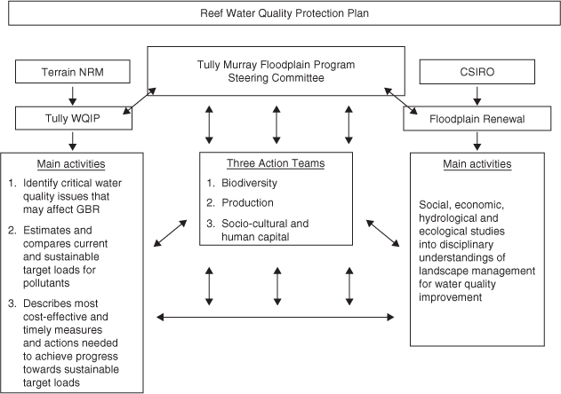
Under the Reef Water Quality Protection Plan (‘Reef Plan’), water quality improvement plans (WQIPs) have been developed for most catchments in the GBR region, including the Tully basin (Anonymous 2003; Kroon 2009). The development of WQIPs is the responsibility of decentralised regional natural resource management (NRM) bodies, under contracts from a highly centralised organisation, the Australian Government. Agreement and support for WQIP development and implementation is sought from relevant local stakeholders, including State and Local Governments, thereby forming an agreed approach to achieving pollutant reductions. Importantly, WQIPs are voluntary and recommendations derived from the development of WQIPs have no statutory power. In the case of the Tully WQIP, the regional NRM body (Terrain NRM) and the Commonwealth Scientific and Industrial Research Organisation (CSIRO) instigated the establishment of the Tully Murray Floodplain Program (TMFP) (Fig. 1) to coordinate and develop the plan. Throughout the Tully WQIP development and delivery, the TMFP framework was used as a point for inclusive knowledge presentation, integration and debate.
Analysis of knowledge integration
The focus of the knowledge integration and translation process was to identify priority measures and actions to contribute to the Reef Plan’s goal of ‘halting and reversing the decline in water quality entering the Reef within 10 years’ (Anonymous 2003). Our research approach draws on the methods used by Margerum and Whitall (2004) who also negotiated the complementary perspectives offered by internal and external perspectives on a water planning process in the USA. It takes a collaborative research approach advocated by Forester (1999) and others whereby an alliance between researchers and planning practitioners is forged to probe and learn from the day-to-day practice of ordinary planning work to provide insights to planning theory and planning practice. This necessarily involves mixing data collection methods and data analysis procedures within the research process.
We facilitated knowledge contributions as part of the broader effort to negotiate effective water quality target and delivery options with members of the TMFP (Robinson et al. 2009). Facilitated discussions focused on findings and uncertainties that existed from available science (e.g. Brodie et al. 2009), the challenge of representing and locating water uses and values of community members (see Bohnet and Kinjun 2009), and the need to ensure available knowledge could inform actions that could be achieved within the institutional context of the water quality improvement program.
Three focus groups were facilitated among stakeholders. These comprised the banana industry representatives and growers, canegrower representatives and Council officers respectively. Each group included members of the TMFP and were chosen because they were identified as key partners involved in the delivery of proposed management action targets under the WQIP (Robinson et al. 2009). In each of these forums, stakeholders were encouraged to share their views of water quality problems and feasible solutions based on their own local knowledge, experiences and understanding of the best available science.
Results
Science contributions and uncertainties
The Tully WQIP is the first WQIP in Australia that specifically links receiving water quality guidelines (chlorophyll a) with end-of-river loads (dissolved inorganic nitrogen, DIN) and land use and management (fertiliser use) (Brodie et al. 2009). The capacity to model these linkages, and develop management targets, was enabled by long-term monitoring datasets, including monthly summer records of chlorophyll a concentrations across lagoonal waters since 1992 (Brodie et al. 2007) and DIN data collected (1988–2000) at the Euramo bridge (Furnas 2003). Further monitoring conducted as part of the Tully WQIP development enabled cross-validation of modelling results (GBRMPA 2008; Bainbridge et al. 2009). These linkages supported the development of cost-effective land management recommendations using scenario modelling (Roebeling et al. 2009) and acceptance of their implementation, to achieve progress towards sustainable DIN loads. They also highlighted that the GBR water quality guideline for chlorophyll a will not be achieved with complete adoption of recommended management action targets (Kroon 2008; Brodie et al. 2009).
Long-term monitoring and associated modelling capacity to link catchment to reef information are not available for other pollutants. This includes suspended sediments, nitrogen species other than DIN, phosphorus species and pesticides. Consequently, recommendations for improvements in water quality in the Tully WQIP were largely driven by practical and achievable management changes within current land use, rather than by an effect-based policy for the GBR (Ferrier 2006). Development of catchment-to-reef models for these pollutants, in combination with comparative risk assessment, will contribute to more effective management interventions to achieve water quality improvement towards sustainable loads for the GBR. Time-lags between implementation of management practices and changes of pollutant loads or concentrations at end-of-rivers will need to be considered in any model linking catchment to reef.
Current loads of suspended sediments, nitrogen, phosphorus and pesticides in surface waters in the Tully–Murray basin are most likely underestimated (Armour et al. 2009; Wallace et al. 2009). Depending on the pollutant, over-bank floods may deliver a substantial amount to the GBR in addition to the currently estimated annual riverine loads. The largest nitrogen fraction in over-bank flood waters is dissolved organic nitrogen (DON), as opposed to DIN in riverine flood waters (Bainbridge et al. 2009), with the main source most likely to be from upper catchment rainforest (Wallace et al. 2009). Hence, management actions to progress towards achieving sustainable DON loads for the GBR require interventions that slow down and reduce drainage rather than improved fertiliser management.
The marine receiving waters influenced by discharge from the Tully–Murray basin was initially estimated as ~2000 km2 (Kroon 2008), with the exact area depending on the volume and duration of flow, as well as the direction of currents and winds (Devlin and Schaffelke 2009). This receiving water body is also affected by flood plumes from rivers further south (Herbert and Burdekin Rivers; Devlin and Schaffelke 2009). Thus, implementing management actions in the Tully–Murray basin alone may not be sufficient to improve water quality towards achieving sustainable loads for their receiving waters. Moreover, recent satellite imagery shows that plumes from Wet Tropics rivers, including the Tully, can extend eastwards across the entire reef shelf and beyond into the Coral Sea (Devlin and Schaffelke 2009). This spatial extent needs to be validated in the field to appropriately define the area of the influence of the Tully–Murray basin.
Local knowledge contributions and uncertainties
The collaborators involved in the TMFP partnership strove to capture local knowledge about the history, state and values of water quality in the catchment. Although there was broad consensus that water quality had deteriorated in the last couple of decades, there was less agreement about the specific causes of water quality decline, the location and priority of environmental values that required protection in the basin, and the required programs of action required.
Results from interviews and workshops identified that all groups use and value the aquatic ecosystems that local waterways (including the GBR) provide, as well as their drinking water and aquatic food values (Bohnet and Kinjun 2009). Differences and potential conflict between the various values are often between ‘consumptive’ (e.g. irrigation) and ‘non-consumptive’ (e.g. recreational and cultural) uses. Such conflict may be further exacerbated by differences in community perceptions regarding the state of water quality and aquatic ecosystems. Specific issues and threats related to uses and values of local waterways were also identified in the interviews and workshops (Bohnet and Kinjun 2009).
Uncertainty about the application of the community’s uses and values of local waterways arose during the Tully WQIP development. The identified uses and values for the GBR were used to establish the environmental values and water quality objectives for the GBR, following national frameworks and state legislation (Bohnet and Kinjun 2009). However, given that the GBR is on the World Heritage List in recognition of its outstanding natural values, the default water quality objectives for the GBR needed to be water quality guidelines and standards that protect its aquatic ecosystem values (e.g. GBRMPA 2008). Moreover, uncertainty still remains about the State Government’s application of environmental values and water quality objectives, which can be scheduled under state legislation in a WQIP framework that is voluntary and has no statutory power.
The interview and workshop participants identified economics at farm and local government levels as one of the main drivers causing landscape, land-use and environmental change having an impact on water quality and quantity (Bohnet and Kinjun 2009). Participants provided several suggestions to mitigate these impacts, indicative of the importance placed on water quality as a well-being factor (Larson 2008), as well as the community’s aspirations and commitment to improve water quality in the Tully–Murray basin. These suggestions were taken into account in the development of management actions for the Tully WQIP (Kroon 2008).
The need to reduce nitrogen fertiliser run-off from farms was acknowledged by agricultural stakeholder groups (Robinson et al. 2009; Roebeling et al. 2009). Management practices that could potentially reduce nitrogen fertiliser run-off were identified through workshops, interviews and questionnaires with industry partners and experts (Roebeling et al. 2009). The cost-effectiveness of these management practices was subsequently assessed in land management change scenarios (Roebeling et al. 2009). Considerable uncertainty, however, surrounded the current uptake of these (and related) management practices, with estimated adoption rates differing widely between farmers and industry experts. Workshops with agricultural and local council stakeholder groups provided insights into feasibility and equity issues surrounding the delivery of proposed water quality objectives (Robinson et al. 2009). Landholders emphasised that local industry knowledge needs to continually inform the design and timing of fertiliser management targets and associated incentive programs. This requires ongoing dialogue so that management programs are acceptable and realistic for agricultural production systems operating in this landscape, and are responsive to the dynamics of landholder capabilities and livelihood needs (Robinson et al. 2009).
Discussion
The practice of knowledge integration for the Tully water quality planning process highlights the challenge of integrating and translating scientific knowledge and local perspectives and values into strategic and effective environmental decision-making. In dynamic biophysical and social environments, such as far-northern Queensland, the generation of both scientific and local contributions takes time (McDonald and Roberts 2006). This may be due to limits in available data or the need for considered deliberation and discussion that underpin local views and decision-making. In the Tully, the time taken to fill certain knowledge gaps caused significant delays to enable other knowledge contribution and integration activities. It also reflects the broad planning context in which management decisions are negotiated, which in turn is affected by the degree to which the collaborative efforts nurture the culture of knowledge sharing, learning and change (Berkes 2007; Muro and Jeffrey 2008). A clearer and more consistent policy and delivery framework of State and Federal governments could have contributed to a more integrated and influential approach to water quality planning in the Tully and across the GBR.
One of the main challenges in using different sets of knowledge to underpin environmental decisions revolves around knowledge translation into management programs and responsibilities (Lane and McDonald 2005). The establishment of a durable partnership (i.e. TMFP) enhanced knowledge integration at the catchment scale, and provided a framework for coordinating and integrating large amounts of fragmented and uncertain information from research, community, government and industry. This process, combined with the socio-political knowledge of the regional NRM body and industry groups, was crucial in securing initial Government resources to commence WQIP implementation. The effectiveness of this process to achieve planned outcomes does need to be assessed against other decentralised and centralised planning approaches (Koontz et al. 2004). The lack of (sustained) participation by some stakeholder groups responsible for and/or affected by water quality issues, contributed to the knowledge integration challenge. This prolonged necessary collaborative planning and management efforts for almost a year. Moreover, unequal knowledge–power dynamics were evident as Government agencies delayed contributions and commitment to planning discussions, scientific evidence was contested by local landholders, and local knowledge struggled to translate into catchment-wide and Reef water quality decision-making.
Biases in scientific and local knowledge contributions can lead to tensions in the knowledge integration and translation process (cf. Fischer 2000; Corburn 2003). In the case of the Tully WQIP, local uses and values that reflected inland basin priorities for the local community (Bohnet and Kinjun 2009) did not match the scientific studies focused on the decline of water quality entering the GBR (Bainbridge et al. 2009). Early TMFP discussions were dominated by the erosion damage caused to riverbanks and locally important waterholes by floods and feral pigs, placing sediment management as the key priority for local Tully communities. Yet scientific studies indicated that nitrate and herbicides are the key pollutants delivered from the Tully–Murray basin to the GBR (Bainbridge et al. 2009). Given the focus of Reef Plan WQIPs to improve water quality to the GBR, combined with public investment in WQIP recommendations, the key priorities had to focus around improved fertiliser and herbicide management.
Our experience highlights that decentralised planning organisations, such as regional NRM bodies, are limited in their capacity to facilitate the integration and translation of scientific and local systems of knowledge at the catchment and Reef scales (cf. Lane et al. 2004). Cash et al. (2002) highlight that a central question that needs to be addressed here is whether collaborative groups can effectively help ‘manage the boundaries’ to ensure that salient, credible and legitimate knowledge informs decision-making for sustainable development. This became particularly evident in the integration and translation of identified community uses and values of local waterways into environmental values and water quality objectives that the State Government is obliged to protect under state legislation. This process created tensions when the knowledge shared and negotiated within the context of a scientific study (Bohnet and Kinjun 2009) was retranslated into a planning process to inform WQIP decisions. For devolved planning approaches to have significant management and policy influence, knowledge used needs to be clear and negotiated, in support of such approaches (Margerum and Whitall 2004; Healey 2006). A consistent approach to the development of WQIPs across the GBR would have facilitated strategic water quality management at a GBR scale that addressed the unique land management issues facing each region. Moreover, such an approach would have clarified how the sum of WQIP regions would contribute to water quality improvement for the complete World Heritage coastal lagoon, a critical issue that remains unresolved.
In summary, the integration of different forms of knowledge to inform strategic environmental decision-making is a critical challenge facing efforts to decentralise planning decisions to non-statutory organisations (Healey 2006). Although desirable, in practice this ideal is difficult to achieve (Cash et al. 2002). The knowledge integration experience that underpinned the Tully WQIP process highlights some of these challenges, in particular the need to ensure planning processes make explicit both if and how knowledge systems are used to inform programs of action. This would require more sophisticated decision-making systems that can better address the politics and power dynamics that underpin knowledge claims and translation into planning practice (Forester 1989). Such approaches can build the capacity in environmental governance to be responsive to uncertainties inherent in challenging environmental management environments that exists in regions such as the Great Barrier Reef.
Acknowledgements
This work is part of the Coastal Catchment Initiative, Natural Heritage Trust, funded by the Department of the Environment, Water, Heritage and the Arts. Additional funding was provided through the CSIRO’s Water for a Healthy Country Flagship Program and the Marine and Tropical Sciences Research Facility. The authors acknowledge Marcus Lane, Rachel Eberhard, Stewart Evans and one anonymous reviewer whose feedback improved earlier versions of the manuscript.
Armour, J. D. , Hateley, L. R. , and Pitt, G. L. (2009). Catchment modelling of sediment, nitrogen and phosphorus nutrient loads with SedNet/ANNEX in the Tully–Murray basin. Marine and Freshwater Research 60, 1091–1096.
Corburn, J. (2003). Bringing local knowledge into environmental decision making. Journal of Planning Education and Research 22, 420–433.
| Crossref | GoogleScholarGoogle Scholar |
Healey, P. (2006). Transforming governance: challenges of institutional adaptation and a new politics of space. European Planning Studies 14, 299–320.
| Crossref | GoogleScholarGoogle Scholar |
Kroon, F. J. (2009). Integrated research to improve water quality in the Great Barrier Reef region. Marine and Freshwater Research 60, i–iii.
Margerum, R. D. (2007). Overcoming locally based collaboration constraints. Society & Natural Resources 20, 135–152.
| Crossref | GoogleScholarGoogle Scholar |
Roebeling, P. C. , van Grieken, M. E. , Webster, A. J. , Biggs, J. , and Thorburn, P. (2009). Cost-effective water quality improvement in linked terrestrial and marine ecosystems: a spatial environmental–economic modelling approach. Marine and Freshwater Research 60, 1150–1158.
Robinson, C. J. , Taylor, B. M. , Pearson, L. , O’Donohue, M. , and Harman, B. (2009). A SMART assessment of water quality partnership needs in Great Barrier Reef Catchments. Australasian Journal of Environmental Management 16, 84–93.
Wallace, J. , Stewart, L. , Hawdon, A. , Keen, R. , Karim, F. , and Kemei, J. (2009). Flood water quality and marine sediment and nutrient loads from the Tully and Murray catchments in north Queensland, Australia. Marine and Freshwater Research 60, 1123–1131.
