

Challenges and lessons learnt from Northern Territory (NT) Orphan Well project
Shaun Hingerty A *A Department of Industry, Tourism and Trade, Darwin, NT, Australia.
The APPEA Journal 63 S192-S197 https://doi.org/10.1071/AJ22160
Accepted: 27 March 2023 Published: 11 May 2023
© 2023 The Author(s) (or their employer(s)). Published by CSIRO Publishing on behalf of APPEA.
Abstract
The Orphan Well project evolved from recommendations in the Final Report of the NT Hydraulic Fracturing Inquiry (HFI). The purpose was to assess wells that were drilled under petroleum permit or licence, and which had subsequently been surrendered by the titleholder and are now the responsibility of the NT Government. The project’s objective was to confirm the current status of these wells and to put forward recommendations for remedial works and/or monitoring for wells assessed to have an integrity risk. The assessment primarily focusses on the risk of fugitive methane gas. Two petroleum engineers were employed to undertake the project of assessing 113 orphan wells scattered over 1.4 million km2 of the NT. As it is a requirement to rehabilitate the land after petroleum activities have ceased, access to orphan wells is often not maintained; therefore, logistical consideration was undertaken. The project involved an initial desktop study of well history (construction) followed by a field site inspection. The drilling of these wells date back to the 1960s. These older wells can often have less detail in the well records including survey location, and being pre-GPS, may include location errors of several kilometres. Remote helicopter travel was used to undertake fieldwork and to locate these wells. The site inspections commenced in February 2022 and as at 31 December 2022 on ground field inspections were delivered to 96 wellsites. This paper provides insight as to how the Orphan Well team developed its processes in both desktop study and site investigations.
Keywords: fugitive methane gas, GPS, laser methane detector, magnetometer, Northern Territory, orphan wells, survey inaccuracy, well failure model, wellbore diagram.
Introduction
The Orphan Well project evolved from the recommendation in the Final Report of the NT Hydraulic Fracturing Inquiry (HFI) (Pepper et al. 2018). For this project an orphan well is defined as a well that has been drilled for the purposes of petroleum exploration or production on some form of title granted under the Petroleum Act 1984 (NT) or its antecedent legislation where the title has been surrendered to the NT Government.
The project’s objective is to assess the ‘well integrity’ status of these wells (Fig. 1) and their risk of releasing methane to the atmosphere. Based on this assessment, where necessary, recommendations for any remedial actions to restore integrity and/or future monitoring of wells will be made.
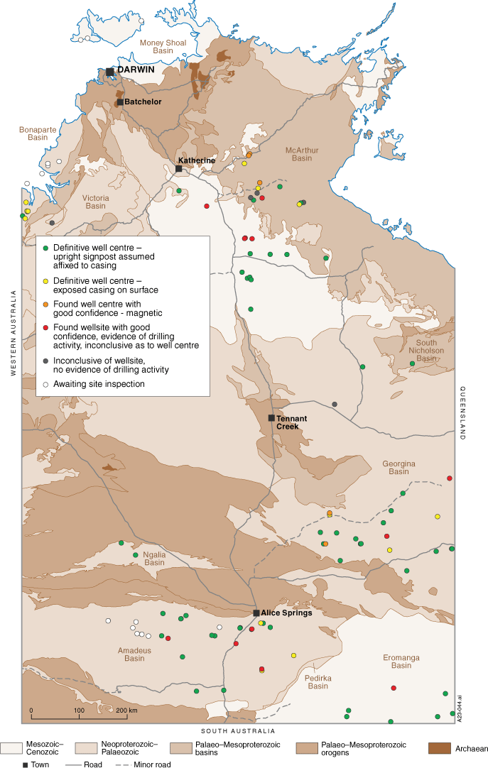
Map of Northern Territory with orphan wells. In all, 96 of 113 orphan wells scattered over 1.4 million km2 of the NT have been inspected to date.
Orphan wells continue to grow in relevance as the issues surrounding them are recognised by many jurisdictions both domestically and internationally. The NT project provides a case history lesson for others undertaking similar challenges.
Preparatory work
In September 2021 the Orphan Well team commenced work on this project. Preparatory work was undertaken prior to and during site inspections. This work involved:
Assessing each of the wells for their risk of releasing methane to the atmosphere – this was termed the initial desktop study.
Analysing the well location and access requirements.
Scheduling well inspection program and travel logistics, and Health Safety and Environment (HSE) considerations.
Notifying and consulting with relevant stakeholders, including Aboriginal Land Councils and pastoralists.
Consulting with Aboriginal Area Protection Authority (AAPA) to identify culturally sensitive areas.
Procuring software to build well barrier diagrams.
Initial desktop study
The risk ratings method used in the initial desktop studies is in alignment with a report commissioned by the CSIRO’s Gas Industry Social and Environmental Research Alliance (GISERA) which is titled ‘Long-term monitoring of decommissioned onshore gas wells’ (Huddlestone-Holmes et al. 2022). To determine the risk rating, information came from multiple sources including well completion reports, correspondence both online and hardcopy from archives.
The risk rating of each well applied to the probability of methane being released into the atmosphere is dependent on the following criteria:
Presence of hydrocarbons as determined when the well was drilled and evaluated.
Hydrocarbon mobility which can be identified by assessing the formations permeability, pressure and if available well test data.
Review of the integrity of well barriers to identified flow zones.
Assessments were made based on numerically weighting the above criteria to indicate a level of risk.
Location determination
Alongside the initial desktop study, records were investigated to ascertain the geographical location of the wells. A number of these wells date back to the 1960s. The survey technology of the day included inaccuracies as great as 2 km between historical published coordinates and the actual locations of the wells.
Resources employed to refine the locations include:
Energy Development Information System (EDIS) database.
Tenure and Geoscience Information Map (Strike) (http://strike.nt.gov.au/wss.html).
Department of Environment Parks and Water Security (DEPWS) records from locations resurveyed – typically as water well records and in NR Maps (https://nrmaps.nt.gov.au/).
Northern Territory Geological Survey (NTGS) published reports on Geoscience Exploration and Mining Information System (GEMIS) which can contain more recent survey information (https://geoscience.nt.gov.au/gemis).
Earth observation imagery software like Google Earth and United States Geological Survey (USGS)’s archive of data.
Review seismic line(s) as these can be identifiable from aerial view in some cases.
Information from stakeholders (Petroleum Operators, Pastoral Owners).
DEPWS’s pastoral lease infrastructure maps.
Scheduling, logistics and HSE considerations
A well inspection schedule was prepared in advance to allow time to notify stakeholders and to determine how the sites could be accessed, i.e. by road or by air with helicopters. The north of the Territory can be susceptible to monsoons between the months of November and April and as such scheduling of these inspections north of Tennant Creek were planned outside of this time window. This was necessary as flooding in the north of the NT during the wet season could possibly cut off access to sites.
Given the conditions in the NT, the uniqueness of some sites and the remoteness of the locations, special precautions and training were taken, including:
Water and electrolyte supplements were standard in field kits due to oppressive heat and/or humidity (temperatures could be in the high forties (°C)).
Proper PPE should be worn including sun hats, sun glasses, boots, long trousers, long-sleeve shirts and snake gaiters.
Remote first aid training.
4WD training.
Weed inspection training.
Cultural awareness training.
Drone pilot training.
Stakeholder engagement and AAPA review
After the relevant stakeholders were identified, inspection schedules were made transparent through frequent communications between parties. Stakeholders were often a source of support for the planning and undertaking of inspections.
Relevant stakeholders included the following:
Central Land Council (CLC)
Northern Land Council (NLC)
Tiwi Land Council (TLC)
Petroleum Titleholders
Pastoralists
NT Cattleman’s Association (NTCA)
The Parks and Wildlife Division of DEPWS
NT Government Heritage Branch
DEPWS
Department of Infrastructure Planning and Lands (DIPL).
There were also checks required through AAPA to identify culturally sensitive areas on the locations which were inspected. A buffer distance surrounding the expected well centre was included to accommodate inaccurate survey coordinates.
Well barrier software
The AutoWells software and Well Failure Model (WFM) tool were procured as the software to create well barriers schematics. The final well barrier schematics format follow the standards NORSOK D-10 (Standards Norway 2021) and ISO 16530-1 (International Organization for Standardization 2017).
Site inspections
Site inspections address four basic categories:
Proximity to the community and ongoing land use activities.
Verification of the location of the well, with the following used to confirm the well’s location onsite:
Methane measurements around the well.
Visually confirming the state of the wellsite.
Methane measurements were made using a Methane Mini Laser. A reading above 100 ppm.m was chosen by the Orphan Wells team after discussions with CSIRO to be an indication of an anomaly requiring further investigation.
Where standard means of locating a well have failed, then remote sensing technology has been considered for use in narrowing down the possible locations of a wellsite. Further, the use of drones has also been considered as they can be programmed to photograph a large area, after which the photos can then be analysed for anomalies.
Results
As at the end of December 2022:
Observed methane gas readings on surface did not identify a need for immediate well intervention.
In all, 93 of 113 wells have had an initial desktop study completed of which 15 wells identified as having a higher risk potential.
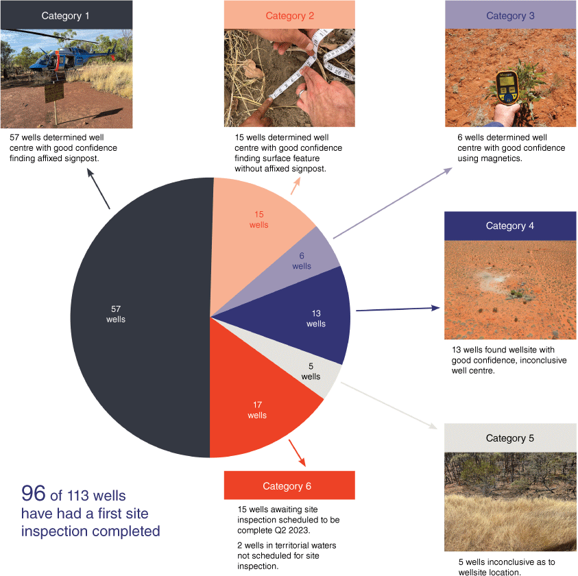
In all, 96 of 113 wells have had a first site inspection completed and results (Fig. 2).
One well was found to have elevated methane readings (>100 ppm.m but <200 ppm.m @ 1 m).
All remaining wells recorded low methane readings for both well centre and associated background.
Approximately 18 800 km of helicopter distance has been flown.
No HSE events.
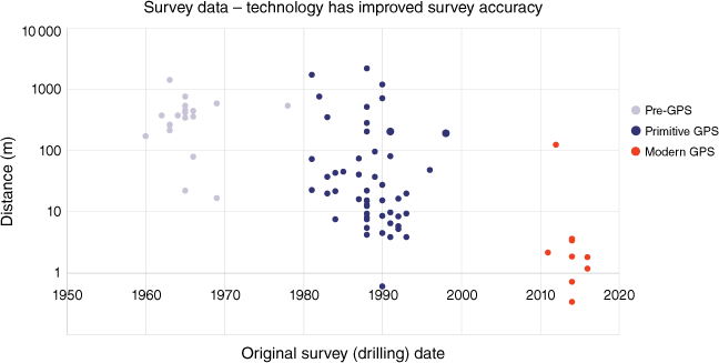
The variance of actual well locations compared to recorded survey coordinate versus date of these original operations (Fig. 3). The actual well locations determined from site inspection using handheld GPS.
Survey data – technology has improved survey accuracy. XY chart of variance between of actual well centre survey as compared to the EDIS recorded values. Errors of hundreds of metres for pre-GPS (1980s) data were as expected. Outlying data particularly evident in period 1980–2000 of variance greater than 500 m. Post 2010 survey repeatability within several metres with the exception of 1 data point.
Lessons learned
Preparedness
The accuracy of recorded well location coordinates should be questioned and verified where possible, before undertaking an inspection. Checking satellite imagery and date/method of survey would also be beneficial.
Stakeholder engagement has been critical in fostering understanding, gaining local knowledge of well locations and ensuring there is no interference with landholder activities and culturally sensitive locations.
The desktop study is highly forensic in nature drawing from many different sources of information which can be incomplete and inconsistent in many cases. It is essential that a risk assessment methodology incorporates various well conditions, drilling observations, well abandonment and well inspection data to allow an overall well risk to be derived.
As a result of different construction standards used over time, the validation of barriers was in most cases poorly verified and recorded.
Wellbore diagrams have proven to be of very low quality with insufficient information on a well’s true as-built condition.
Site inspection operations
Based on well inspection results there has been no indication of a loss of integrity at surface.
Utilising a helicopter to get an overview of sites can assist with identifying anomalies which can help in determining the location of a well.
The use of helicopters to visit wellsites greatly increased the number of wells which can be inspected particularly over large distances where well locations are scattered and inaccessible by road.
Future decommissioning
The amended Petroleum Act 1984 which commences Q2 2023, as a result of the Hydraulic Fracturing Inquiry (HFI), requires that decommissioned wells be considered in well operations management plans.
Well decommissioning requirements will include clear instructions on how a well’s location should be marked.
Detailed decommissioning records must be kept to ensure the status of the well is clearly understood, and can be re-evaluated in the future should any anomaly occur in terms of safe containment.
Accurate wellbore diagrams for all orphan wells which include well barrier validation information. It is important that stratigraphic information is included identifying hydrocarbon-bearing zones and aquifers.
Acknowledgements
The author would like to acknowledge the traditional custodians of the country where this work was undertaken, and to thank the land councils and the pastoralists for their support. The author would also like to acknowledge the work done by the Orphan Well team, specifically Ibrahim Hussien and Alireza Dianati.
References
Huddlestone-Holmes CR, Arjomand E, Kear J (2022) Long-term monitoring of decommissioned onshore gas wells. CSIRO Report EP2022-1246. (CSIRO: Australia)| Crossref |
Pepper R, Anderson A, Ashworth P, Beck V, Hart B, Jones D, Priestly B, Ritchie D, Smith R (2018) Final Report of the Scientific Inquiry into Hydraulic Fracturing in the Northern Territory. Available at https://frackinginquiry.nt.gov.au/inquiry-reports/final-report
International Organization for Standardization (2017) Petroleum and natural gas industries — Well integrity — Part 1: Life cycle governance. ISO 16530-1. (International Organization for Standards)
Standards Norway (2021) NORSOK Standard D-010. Well integrity in drilling and well operations. Rev. 5, 5th edn. (Standards Norway)

Shaun Hingerty is currently employed by the Northern Territory Government in the role of Senior Orphan Wells Engineer. This project was initiated from the Northern Territory Hydraulic Fracturing Inquiry’s recommendation. Shaun has over 25 years of oil and gas industry experience in both Service Company and Operator affiliations. He has worked for companies such as Halliburton, Roc Oil and Bridgeport Energy, principally involved in drilling construction and life-cycle well operations in roles of engineering, supervision and management. Current interests include well integrity, repurposing of petroleum wells and geothermal. Shaun holds both a Bachelor and a Master's degree in Petroleum Engineering and is a Chartered Registered Engineer. He is an active member of Society of Petroleum Engineers and Engineers Australia. |