

Underexplored but not forgotten: assessing the energy resources potential of the greater Pedirka Basin region through play-based mapping
Jeremy Iwanec A * , Paul Strong B and Tom Bernecker AA Geoscience Australia, Canberra, ACT, Australia.
B South Australian Department for Energy and Mining, Adelaide, SA, Australia.
The APPEA Journal 63 S251-S256 https://doi.org/10.1071/AJ22150
Accepted: 24 February 2023 Published: 11 May 2023
© 2023 The Author(s) (or their employer(s)). Published by CSIRO Publishing on behalf of APPEA. This is an open access article distributed under the Creative Commons Attribution 4.0 International License (CC BY).
Abstract
The Pedirka, Simpson and western Eromanga basins in central Australia have had a chequered exploration history which has seen only 42 wells drilled across a study area of ~210 000 km2. Exploration initially focused on conventional hydrocarbons from the 1950s–1980s, before shifting towards coal seam gas (CSG) opportunities in the mid-2000s. Active petroleum systems have been proven in the region by a non-commercial oil discovery at Poolowanna 1 in 1977, and by several wells that showed evidence of residual oil columns. CSG exploration programs have confirmed the presence of thick, marginally mature coal intervals on the flanks of the basins, but are yet to evaluate the CSG potential of the deeper troughs. Geoscience Australia, the Northern Territory Geological Survey and the South Australian Department for Energy and Mining have been collaborating on the Australia’s Future Energy Resources project to undertake an assessment of the resource potential for conventional and unconventional hydrocarbons, and the geological storage of CO2 (GSC) potential of the greater Pedirka region. The project has applied a play-based exploration approach to qualitatively assess the resource potential of the region. The Carboniferous to Cretaceous stratigraphic interval was divided into 14 plays which were evaluated for the presence of sediment-hosted energy resources through post-drill analysis, gross depositional environment mapping and common risk segment mapping. The analysis identified energy resources and GSC potential across multiple plays and locations within the study area. These results demonstrate, that while the region is underexplored, it should not be overlooked by future exploration activities.
Keywords: conventional hydrocarbons, geological storage of CO2, Pedirka Basin, play-based exploration, prospectivity, Simpson Basin, unconventional hydrocarbons, western Eromanga Basin.
Introduction
As part of the Australian Government funded Exploring for the Future (EFTF) program, Geoscience Australia, in collaboration with the South Australian Department for Energy and Mining and the Northern Territory Geological Survey, is conducting a 4-year multidisciplinary study to investigate the energy resource potential of selected onshore basins within central Australia under the Australia’s Future Energy Resources (AFER) project. The AFER project has four modules. This paper focuses on Module 1 which is undertaking a basin-scale resource assessment of the greater Pedirka Basin region (Fig. 1) through play-based exploration (PBE) and common risk segment (CRS) mapping. The PBE approach has been applied by the petroleum industry for several decades and has been adapted by Geoscience Australia to assess multiple sub-surface sediment-hosted energy resources.
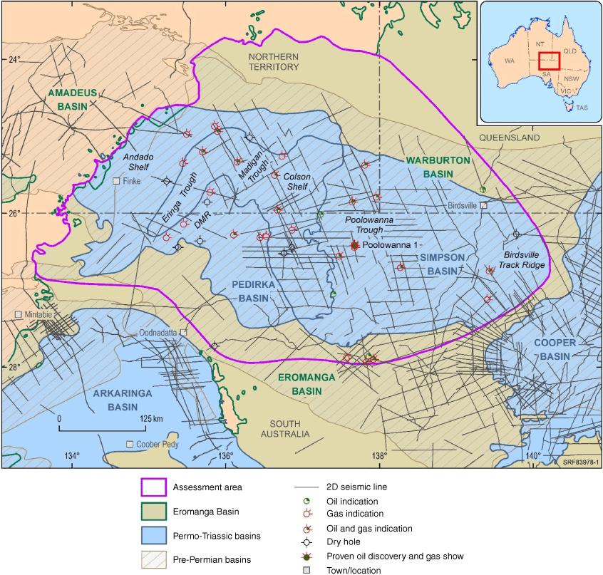
AFER project assessment area showing wells used in the study, 2D seismic data coverage, the extent of Permian and Triassic depocentres and the main structural elements (DMR = Dalhousie-McDills Ridge).
This paper presents the workflow and preliminary results of a qualitative assessment for conventional and unconventional hydrocarbons and geological storage of CO2 (GSC) opportunities within the Pedirka, Simpson and western Eromanga basins of the greater Pedirka region, referred to as the ‘assessment area’.
Geological framework
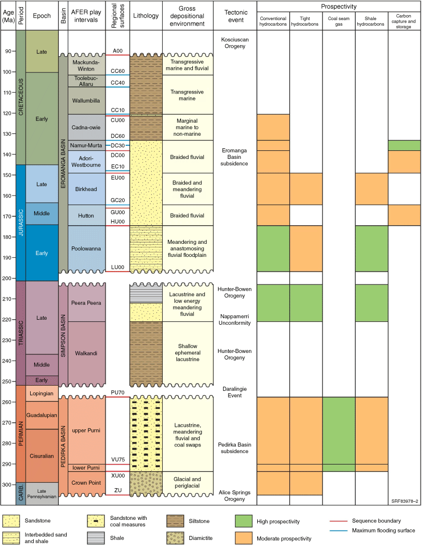
The assessment area covers ~210 000 km2 (Fig. 1) and consists of several stacked basin sequences including the Neo-Proterozoic to Devonian Amadeus and Warburton basins, the Permo-Carboniferous Pedirka Basin, the Triassic Simpson Basin, the Early Jurassic to Late Cretaceous Eromanga Basin and the Cenozoic Lake Eyre Basin (Fig. 2). The AFER study has focused on the Carboniferous to Cretaceous sequences, which are dominated by Carboniferous to early Permian glacial and peri-glacial sediments, Permian to Early Cretaceous lacustrine and fluvial systems, and Early to Late Cretaceous marine systems (Ambrose et al. 2007). Tectonically, the region has undergone uplift, folding, erosion and subsidence associated with orogenic and post-orogenic subsidence phases of the Hunter-Bowen and Kosciuscan orogenies. Hydrocarbon trap development during these events resulted in low relief anticlinal or low offset tilted fault blocks. Peak hydrocarbon generation and expulsion occurred within the early part of the Late Cretaceous (100–90 Ma) following significant subsidence and deposition of the Winton Formation (Ambrose 2006). Oligocene to Miocene orogenesis associated with plate collisions on Australia’s northern margin, however, has resulted in the overprinting and potential breaching of existing structures.
Exploration history
The assessment area is underexplored with only 42 wells drilled and ~16 000 km2 of 2D seismic acquired since exploration began in the 1950s (Fig. 1). Initial exploration drilling in the 1960s and early 1970s targeted Permian and pre-Permian plays on major basin highs including the Birdsville Track and Dalhousie-McDills ridges. In the late 1970s and 1980s, conventional hydrocarbon exploration shifted to targeting Triassic and Early Jurassic plays in and around the Poolowanna Trough following the discovery of hydrocarbons at Poolowanna 1 in 1977. Poolowanna 1 confirmed the presence of an active petroleum system within the region when oil and gas were recovered from the Triassic Peera Peera and the Jurassic Poolowanna formations. This was followed by the identification of residual oil saturations in several wells, and the presence of oil and gas indications in a number of wells across the assessment area. Conventional hydrocarbon exploration was largely abandoned at the end of the 1980s due to a lack of success, economic conditions and emerging opportunities in the adjacent Cooper Basin.
Exploration activities recommenced in 2008 when Central Petroleum drilled two conventional hydrocarbon wells and embarked on a coal seam gas (CSG) drilling campaign in the western part of the Pedirka Basin. Central Petroleum drilled six CSG wells targeting coals within the Permian Purni Formation. While the wells intersected thick coal intervals, the coals were sub-bituminous and registered very low gas content. Central Petroleum’s evaluation suggested that future developments of these plays would require possible underground coal gasification and/or mining. Coals within the deeper parts of the Eringa Trough however are yet to be evaluated.
Method
Geoscience Australia has adapted the conventional hydrocarbon PBE workflow to assess multiple sub-surface sediment-hosted energy resources. PBE is a method of building and leveraging an understanding of a basin and its petroleum systems by using a systematic approach to integrate geological and geophysical datasets. Various elements that are essential for a resource to exist can be mapped, qualified and stacked through CRS mapping to identify sweet spots in each formation or play. In conventional petroleum exploration, PBE maps the geological elements of source, reservoir, seal and trap. In this study, unconventional hydrocarbon prospectivity was assessed by focusing on the regional quality and continuity as well as the potential producibility of these resources. GSC prospectivity was assessed by focusing on any prospective permanent containment systems that are capable of maintaining commercial injection rates and sufficient storage capacity.
The Carboniferous to Cretaceous stratigraphic interval was divided into 14 play intervals as shown in Fig. 2 (Bradshaw et al. 2022). Each play was then systematically assessed against a series of geological elements and metrics that were defined for each energy resource. The assessments produced quantitatively risked, spatial results for each geological element. These spatial results were then stacked through CRS mapping to identify resource-specific sweet spots in each play.
It is important to note that PBE and CRS mapping provides an interpretation based on existing data to build upon the geological knowledge of a basin. New data or alternate interpretations can therefore have a dramatic impact on the results, particularly in data-poor regions. Also, the elements and metrics used are subjective and will vary from basin to basin, across fluid types, within different petroleum systems and for varying commercial cut-offs. The key value of the PBE process is that it increases the understanding of a basin’s geology and how key elements for the resources interact in a spatial context. The metrics and evaluation process applied by CRS mapping provide a means for decision making.
Results
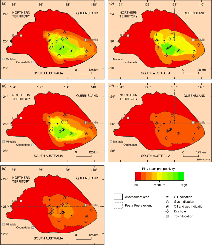
The study identified the potential for conventional and unconventional hydrocarbons as well as GSC opportunities within the assessment area. The qualitative assessment of these results at play level are presented in Fig. 2. The most prospective plays include: the Permian upper Purni, the Triassic Peera Peera, the Early Jurassic Poolowanna and the Early Cretaceous Namur-Murta plays. This paper presents spatial results for the Peera Peera play (Fig. 3).
Composite common risk segment play stacks for the Peera Peera. (a) Conventional hydrocarbons, (b) tight hydrocarbons, (c) shale-hosted hydrocarbons, (d) coal seam gas and (e) geological storage of CO2.
The Peera Peera Formation is a heterogeneous fluvial-lacustrine succession comprising: a lower shale, siltstone and coal succession; a middle fine-grained sandstone succession; and an upper black carbonaceous silty shale interval which is rich in organic matter. The Peera Peera play is considered to be one of the main source intervals for hydrocarbon generation within the assessment area. The play has previously only been targeted by conventional hydrocarbon exploration activities in the 1970s and 1980s and has been intersected by 18 wells. The most significant results have been from the Poolowanna 1 well where gas flowed at rates too small to measure and a slight oil cut mud was recovered from a drill stem test. The play is located within the central part of the Poolowanna Trough, and extends over the Birdsville Track Ridge to the east.
Fig. 3 shows play composite CRS stacks for each of the assessed sediment-hosted energy resources within the Peera Peera play. The mapping indicates moderate to high potential within the Poolowanna Trough for conventional and tight hydrocarbons which are hosted within the middle sequence of the Peera Peera play, and moderate to high potential for shale hydrocarbons which are present within the uppermost succession of the play. GSC and CSG are interpreted as not being prospective within the Peera Peera as the reservoir intervals are too thin and tight for GSC opportunities, while the absence of thick, continuous coal intervals hinder CSG potential. The results suggest that future exploration should continue to focus on conventional hydrocarbons, as well as considering tight and shale hydrocarbon opportunities within the Poolowanna Trough.
Conclusion
Geoscience Australia’s AFER project is aimed at unlocking the potential of underexplored basins in central Australia by providing pre-competitive geological information and spatial datasets. The project’s objective is to produce spatially enabled and risked resource estimates to provide government and industry stakeholders with decision making tools to address the region’s sediment-hosted energy resources and support exploration investment.
The greater Pedirka region has been largely overlooked by petroleum explorers for the past 30 years, partly because of its remote location, and partly because of the sparse, variable quality and dated data coverage. CRS mapping via PBE has qualitatively identified the potential for conventional and unconventional hydrocarbons and GSC opportunities, and highlights that an area that has been primarily explored for one resource type in the past may have alternate resources for industry to evaluate. PBE provides an interpretation at a static point in time, taking all available data to build upon existing knowledge of a basin. New data, interpretation and/or variations in assessment criteria and metrics can therefore have a dramatic impact on the CRS results.
Acknowledgements
The authors wish to thank Barry Bradshaw and Tehani Palu for their constructive reviews, and Chris Evenden for figure drafting. This paper is published with the permission of the CEO, Geoscience Australia.
References
Ambrose G (2006) Northern Territory of Australia, onshore hydrocarbon potential, 2006. Northern Territory Geological Survey, Record 2006-003. Available at https://geoscience.nt.gov.au/gemis/ntgsjspui/handle/1/82437Ambrose G, Scardigno M, Hill AJ (2007) Petroleum Geology of Middle–Late Triassic and Early Jurassic sequences in the Simpson Basin and northern Eromanga Basin of central Australia. The APPEA Journal 47, 127–143.
| Petroleum Geology of Middle–Late Triassic and Early Jurassic sequences in the Simpson Basin and northern Eromanga Basin of central Australia.Crossref | GoogleScholarGoogle Scholar |
Bradshaw BE, Rollet N, Iwanec J, Bernecker T (2022) A regional chronostratigraphic framework for play-based resource assessments in the Eromanga Basin. The APPEA Journal 62, S392–S399.
| A regional chronostratigraphic framework for play-based resource assessments in the Eromanga Basin.Crossref | GoogleScholarGoogle Scholar |

Jeremy Iwanec is a Geoscientist with 20 years of petroleum industry experience. Jeremy completed a BSc (Honours) in Applied Geology from the University of New South Wales in 2002, before joining Oil Search Limited in 2003. At Oil Search, he worked on various projects across Papua New Guinea, Yemen and Kurdistan, undertaking play-based exploration studies, 2D and 3D seismic interpretation, structural and stratigraphic modelling, well planning and delivery, and resource assessments. In 2021, Jeremy joined Geoscience Australia as an Energy Resources Geoscientist where he is currently conducting studies of sediment-hosted energy resources. |

Paul Strong is a Geoscientist with over 35 years of oil and gas industry experience. He is Chief Petroleum Geologist at the SA Department for Energy and Mining, after holding a range of senior technical and managerial positions with Santos Limited for nearly 23 years. His experience includes play-based exploration, prospect generation, drilling operations, reserve/resource estimation and full-cycle economics. Paul holds a BSc (Hons) in Geology from the University of Durham (UK) and an MSc in Petroleum Exploration Studies from the University of Aberdeen (UK). |

Dr Thomas (Tom) Bernecker is a Geoscientist who holds a MSc from the University of Aachen (RWTH), Germany and a PhD from Melbourne’s La Trobe University. His research work focused on the development of models for siliciclastic and carbonate depositional systems in NW Europe and in Australia. After a lectureship at the University of Melbourne, Tom joined the Victorian Department of Natural Resources and Energy where his work was focussed on the hydrocarbon prospectivity of the Gippsland and Otway basins. Tom joined Geoscience Australia in 2007 and is currently the Director of Energy Resources Advice and Promotion. |